CHAPTER 3
|
ARCHTECTURE in
WESTERN ARMENIA
|
TAKEO KAMIYA
BACK NEXT
.

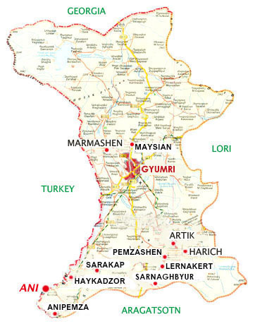
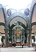
Western Armenia consists of three provinces: Shirak, Aragatsotn and Armavir. Its western border meets Turkey. The ruins of the ancient capital Ani bestride Shirak province and Turkey. I wish one could cross the border easily here. The provincial capital of Shirak is the second largest city in Armenia, Gyumri (Leninakan in the Soviet era) with a population of 170,000.
INDEX
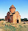
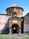
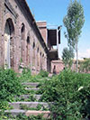
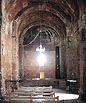
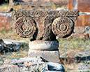
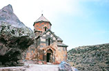
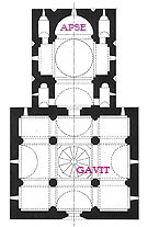
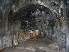
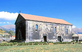
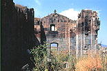
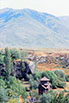
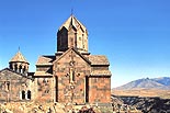
MARMASHEN ***
MARMASHEN VANK ***
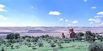
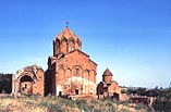 
Marmashen Vank stands in isolation on a barren land. The Gavit of the Katoghike has been lost, and a round church too.
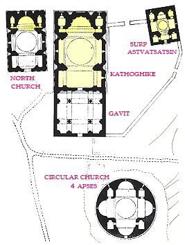
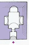
PLAN of Marmashen Vank
(From "Architettura Armena" Paolo Cuneo, 1988, Deluca Editore)
INDEX
MAYSIAN *
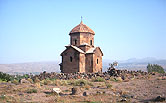
TSIRANAVOR (Surp Astvatsatsin), 7c. *
An early simple crucified church of Surp Astvatsatsin is also called 'Tsiranavor'.
INDEX
GYUMRI (LENINAKAN) **
YOT VERK, 19c. *
The capital of Shirak province, Gyumri was called Leninakan in the Soviet era. It suffered severely by the Spitak earthquake in 1988.
Yot Verk is a Russian orthodox church on the north of the Square. ( PC.118 )
Kumaili Church in the 7th century.
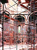
SURP AMENAPRKICH, 19c. *
Surp Amenaprkich is on the south of the Square, still under repair. I could not take photos of its interior due to the scaffolds.
INDEX
ARTIK **
SURP ASTVATSATSIN, 5c.
PLAN of Surp Astvatsatsin
(From "Architettura Armena" Paolo Cuneo, 1988, Deluca Editore)
Artik is a small town with a population of around 20,000, known as a producing center of rose color tufa stone. The church of Surp Astvatsatsin is presumed to have been erected by Kamsarakan family in the 5th century. This very old tufa church was mostly destroyed. It might be a domed church with three naves, though quite small. There remains
the foundations of a single nave church adjacently.
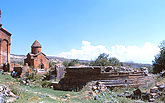
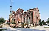
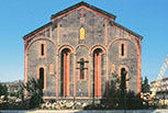
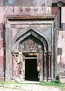
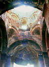
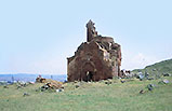
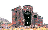
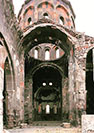
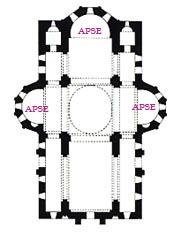
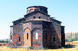
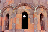
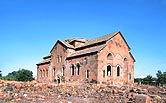
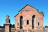
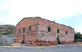
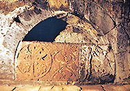
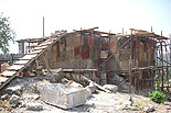
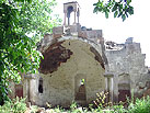
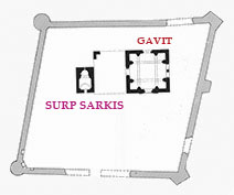
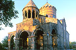
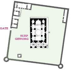
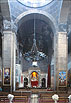
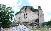
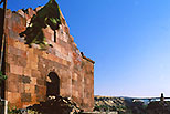
SURP SARKIS (Surp Geworg Katoghike), 7c. *
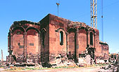
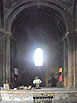
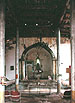
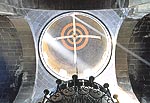
This is the ruins of a large scale Four-apse church, called Surp Sarkis Church or Surp Geworg Katoghike (St. George Cathedral), which is supposed to have been constructed in the 7th century. It is a huge church as long as 25 meters with the central dome of 13 meters in diameter. This largest dome in Armenia and its drum have been collapsed.
  PLAN of Surp Sarkis (Katoghike)
(From "Early Christian Architecture of Armenia" Murad Hasratian, 2000)
PLAN of Surp Sarkis (Katoghike)
(From "Early Christian Architecture of Armenia" Murad Hasratian, 2000)
The west and south apses are pentagonal outside and circular inside, being used as entrances. In the interior are some remains of murals of Apostles and Christ. It has been long continuing the repair, but might not be the entire reconstruction.
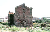
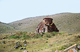
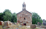
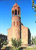
LMBATA VANK (Surp Stephanos), 6c. **
A small church on a northwestern hill of Artik with a good view of the city can be also seen from anywhere of the city.
INDEX
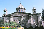
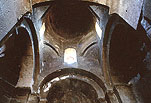
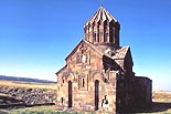
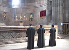
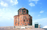
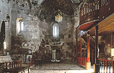
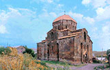
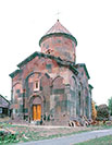
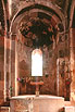
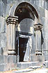
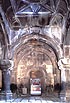
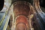
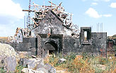
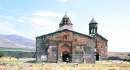
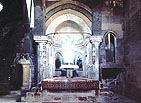
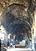
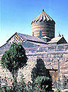
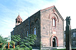
HARICH ***
HARICHA VANK, 1201 ***
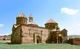 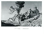
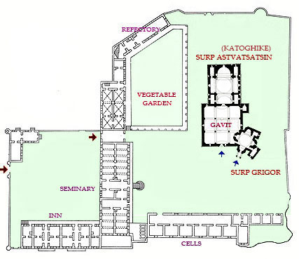
Haricha Vank is a vital monastery still in operation at the village of Harich 4km from Artic. As it has not only quite old churches and modern monks' cells, school, scriptorium, and other facilities from the latter half of the 19th century but also a vegetable garden in its precincts, it is a rare example showing the total aspect of a large Armenian orthodox monastery.
It was the summer residence of Echmiadzin's Catholicos since 1850, and was a monastery facing a ravine like Saghmosa Vank and Hovhanna Vank, though small, but the river on the west of the precincts has dried up and has been filled with sediment, losing the image of a ravine.
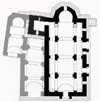
 PLAN of Haricha Monastery
(From "Architectural Ensembles of Armenia" O.Kh. Khalpakhchian)
PLAN of Haricha Monastery
(From "Architectural Ensembles of Armenia" O.Kh. Khalpakhchian)
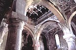
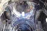
The main building complex looks quite complicated, consisting of the small 7th century church of Surp Grigor Lusavorich and the greater early 13th century church of Surp Astvatsatsin, 20 or 30 years after which was built a gavit. The axes of the two churches are different from each other with a gap of about 20 degrees, the Gavit made a strange connection with the church of Surp Grigor, but the entrance to this church is not from the Gavit but a portico with a belfry constructed in the 13th century. These buildings and a Gavit's Yerdik, over which is a rotunda-shaped roof, make a highly animated view looked at from the front plaza-like courtyard.
@ 
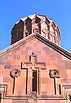
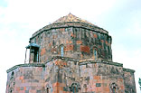
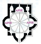
The church of Surp Grigor Lusavorich (Illuminator) is a four-apse church with a similar plan of the churches of Surp Hovhannes in Mastara and Surp Sarkis in Artik near here, though being much smaller in scale than them. Each apse is semicircular inside and pentahedral outside. The church has an enormous tower part considering its small body, opposing to that of the next Katoghike built in the 13th century.
Since the roof over the dome was altered into a hemispherical dome in the 19th century (under the influence of Islamic architecture?), many books still carry photographs of such curious dome roof, but it has been restored into the original conical roof since the restoration at the end of the 20th century. Its drum is twelve-hedral with almost no decorations.
In the 10th century a one story chapel was added on its southeastern side, and in the 13th century two-story chapel was added on its southwestern side. Though the interior of the church was devastated when I visited, It must have been beautifully restored now.
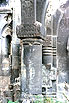
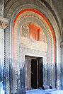
The church of Surp Astvatsatsin is also a Katoghike (Cathedral), constructed in 1201 by Prince Zakarê and his brother Ivanê of the Zakarian family according to an inscription. Its plan is typical in the 12th and 13th-century Armenian churches like the Katoghike of Geghard, putting a cruciform hall surmounted with a dome in a strict rectangular outline with two storied small chapels or sacristies at four corners. This composition is sometimes called the 'Partitioned Cross' form.
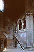
What is special is that the two rooms at a mezzanine floor on both sides of the doorway are galleries having an arcade of four arches on two freestanding columns in front, and a cantilevered stone stairway lead there. It makes a rare space composition in Armenian churches.
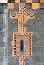
The roof of this church was also altered into a conical roof in the 19th century, as seen in many books' photographs, but was restored into the original umbrella roof in the end of the 20th century. Furthermore, the shape of this roof and the drum is quite rarely twenty-hedral. The drum is extremely decorative with a medallion in each face demarcated by clustered columns, each of which consists of three thinner columns. This manner was succeeded by the churches of Gandzasar (1216-38) and Ohanavan (1216-21).
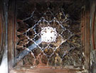
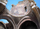
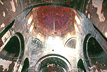
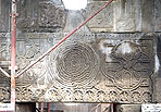
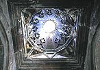
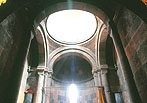
The Gavit was erected by the chamberlain, Prince Vahram Aneci, based on a typical square plan with four central columns, arches on which divides the ceiling into nine bays. Each bay is ornamented with an individual geometric relief pattern and especially the central bay forms a Yerdik decorated overall with muqarnas with a skylight on top. Unlike Persian superficial muqarnas, this elaborate stalactite (muqarnas) sculpture on a true corbelling dome is extremely splendid.
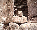
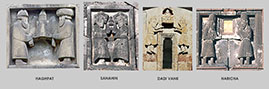
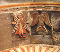
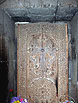
Each facade of the Katoghike is also ornamented fully with elaborate relief sculptures and moldings. A relief panel under the eastern gable depicts a dedication of the church by brothers of the Zakarian family, Princes Zakarê and Ivanê. The similar panels can be seen at several churches in Armenia. I put a catalog of their photos below. At Haricha, the model that two dedicators hold in both hands was replaced with a panel of Virgin and Child in the 19th century.
The Catholicos of Echmiadzin made this monastery his summer residence in the 19th century, expanding the precincts of the monastery and erecting his offices, monks' cells, a refectory and kitchen, a bakery, a school, an inn, and other facilities on the periphery of the precincts. However, it is uncommon that such a broad monastery does not have a graveyard.
Over the Yerdik of the Gavit, bells were once hung from a horizontal bar, later a rotunda-type belfry was built, also functioning as the roof of the skylight.
On the southern side of the two-storied small chapel of the church of Surp Grigor, a larger building, likely another Gavit, was constructed, only a part of which remains nowadays.
INDEX
PEMZASHEN *
SURP GEVORG, 5c.
The northern Basilica in the 5th century, the southern in the 6th century.
INDEX
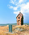
LERNAKERT *
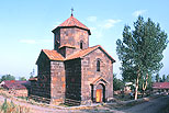
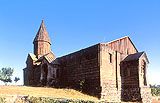
SURP STEPHANOS, 4c.
This is one of the oldest churches in Armenia, the simplest single-nave church of Surp Stephanos at Lernakert village near Artik.
MAKARA VANK (Surp Macarius), 11c. *
The half ruined church of Surp Macarius in the Makara Vank from the 11th century.
There is another ruined church of Sudrp Arakelots near here.

INDEX
SARNAGHBYUR **
HOGE VANK, 13c. *
There are ruins, a new church, and a cave church at Sarnaghbyur village.
INDEX
SARAKAP *
SURP ASTVATSATSIN, 6c.
The four-apse church, interior of which is wooden.

 PLAN of Surp Astvatsatsin at Sarakap
(From "Early Christian Architecture of Armenia" Murad Hasratian, 2000)
PLAN of Surp Astvatsatsin at Sarakap
(From "Early Christian Architecture of Armenia" Murad Hasratian, 2000)
INDEX
HAYKADZOR *
SURP GRIGOR LUSAVORICH
The church of Surp Grigor Lusavorich near Haykadzor village was erected in the 10th century. It is a single-nave church with small sacristies on both side of the apse in a rectangular peripheral wall. Since it is mainly made of reddish brown stone, it was also called Karmir Vank (Red Monastery). The entrance is not on its west but on its southern wall only. Due to its location on the border of Turkey, the church is guarded by soldiers, keeping visitors away from approaching closely.
According to an inscription, it was built in 980-985 by a monk-architect named Samehan. It was for the first time that the word 'Varpet' (architect) appeared in inscriptions.
INDEX
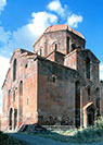
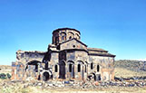
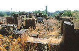
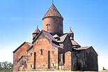
ANIPEMZA **
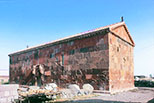
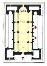
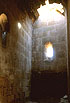
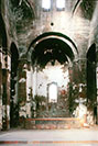
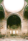
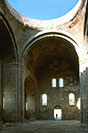
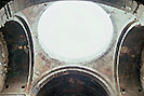
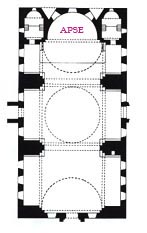
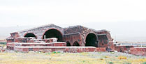
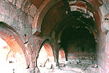
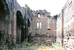
YERERUK BASILICA (Surp Karapet), 5c. **
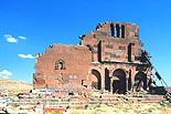 
This is the important ruins of Yereruk Basilica from the 5th century, remaining at Anipemza village near the Akhurian River, which makes Turkish border, and only 5km south from the ruins of Ani in Turkey. The basilica is said to have been dedicated to Surp Karapet (St. John the Baptist). It made once a complex with four commemorative columns, a mausoleum, and an artificial lake.
The first erected Yereruk Basilica with three naves and a protruding apse might have followed the form of the Cathedral Church of Dvin in a smaller scale. The Basilica of Ashtarak in the same era is the same type, and that of Yeghvard in a little late era has a similar plan but no superstructure now.
The Yereruk Basilica got many additions around itself in the 5th and 6th centuries, such as four corner rooms and two galleries on its north and south sides, attaining to a magnificent church with an unprecedented form. However, it has lost the roof and the added parts have been half destroyed nowadays.
 PLAN of the Yereruk Basilica
(From "Armenian Art" Jean-Michel Thierry, 1987, Harry N. Abrams)
PLAN of the Yereruk Basilica
(From "Armenian Art" Jean-Michel Thierry, 1987, Harry N. Abrams)
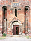
On a stylobate with six steps stands the Basilica, the total length of which is as long as 36m, almost the same scale as the Cathedral of Ani. On the west side is the main facade with three arches on the ground floor with the main portal, and on the south and north sides were four-span colonnaded galleries. The east ends of the galleries are high and narrow apses, and the south gallery has two decorative doorways to the aisles of the basilica.
At each corner of the church is a small room surrounded with massive walls and the basilica had two rows of three T-shaped columns separating the central nave and aisles. The roof is considered to have been a wooden structure. The most attractive features in this church would be the three entrance portals' architectural composition and decoration.
 A reconstruction of the Yereruk Basilica by Tokarskij
(From "Documenti di Architettura Armena, No.9 Ererouk, 1977)
A reconstruction of the Yereruk Basilica by Tokarskij
(From "Documenti di Architettura Armena, No.9 Ererouk, 1977)
 
Putting two massive boxes at the right and left ends and connecting them with an arched portico for the main facade of a church is quite Syrian as at the Basilical church of Qalb Lozeh. The semicircular arch of the main portal is large 2 meters in diameter for intrados, while each of the eastern side portals have 1.5 meters and uncommonly capped with a triangular gable, which reminds us of the portico of the Katoghike of Avan near Yerevan.
INDEX
.
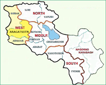
Aragatsotn means the foot of Mt Aragatz, the highest mountain in the Republic of Armenia. Old vanks and remains are densest in this province. The provincial capital is Ashtarak 20km northwest of Yerevan, embracing a population in the census of 2001 of about 20,000.
INDEX
ZARINJA **
CHURCH, 9c. *
A Four-Apse church in Zarinja in the 9th century (or 7th century?).
  PLAN of the church in Zarinja
(From "Architettura Armena" Paolo Cuneo, 1988, Deluca Editore)
PLAN of the church in Zarinja
(From "Architettura Armena" Paolo Cuneo, 1988, Deluca Editore)
INDEX
MASTARA **
SURP HOVHANNES, 6-7c. *
A large dome type church like a Ottoman mosques. much earlier than Ottoman architecture. It has a mezzanine like women' seats in a mosque.
  Plan of Surp Hovhannes
(From "Armenian Art" Jean Michel Thierry, 1989, Harry N. Abrams)
Plan of Surp Hovhannes
(From "Armenian Art" Jean Michel Thierry, 1989, Harry N. Abrams)
INDEX
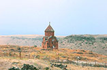
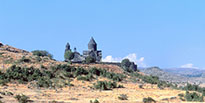
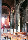
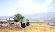
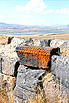
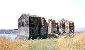
SHENIK **
SURP SARKIS, 7c. *
At 3 km east of Mastara, the erstwhile village of Shenik has disappeared, while the church of Surp Sarkis still stands in solitude by a lake in a prairie. It is the church of Surp Sarkis, also called Surp Astvatsatsin or Dupre Vank. This rectangular single room church was restored in the early 20th century, but its central dome and drum were not regained. In the ruined interior is a wooden frame of posterity.
One more church from the 5th century, Surp Amenaprkich, can be seen in the distance.
INDEX
GARNAHOVIT *
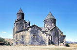
SURP GEVORG, 7c. *
The church of Surp Gevorg is an early Armenian church from the 7th century, surviving at the village of Garnahovit at almost 2,100m above sea level. Surp Gevorg is the soldier saint George who slew a dragon in a legend. The church's exterior and decorations are similar to the church of Mastara, located only 8km southeast from here, but the plan is not a grand dome-type like Mastara but resembles very much that of Surp Hripsime in Vagharshapat of the four-apse type. Apart from the roof, it has been well preserved church on the whole.
In front of the west and south entrances are portals, on the arch of which is a gabled roof. On both sides of the west one are trapezoidal niches with a twin semi-columns at the bottom, over which would have been a statue, a very rare example.
The octagonal drum has as many as 12 windows. As the roof was rebuilt in 1997, the church has regained its complete original form.
INDEX
TALIN **
KATOGHIKE (Surp Astvatsatsin), 7c. **
Talin Katoghike is a hall-type church. How were the apses on both sides used?
  PLAN of the Talin Katoghike
(From "The Armenians" Adriano Alpago Novello, 1986, Rizzoli)
PLAN of the Talin Katoghike
(From "The Armenians" Adriano Alpago Novello, 1986, Rizzoli)
SURP ASTVATSATSIN, 613-5 *
 
5th century single-nave small church
EC : Surp Astvatsatsin-Kamsarakanneri , small church
INDEX
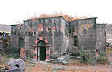
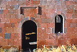
DASHTADEM *
FORTRESS & CHURCH, 7c. *
At Dashtadem village about 6 km south of Talin is the remains of a fortress, which was first constructed in the 10th century and was used until early modern times. Circular and polygonal bastions were added to the ramparts in the 19th century. There are underground rooms under the keep.
At the nearby graveyard is a small church of trefoil (three apses), Surp Kristapori (St. Christopher) from the 7th century. It was recently restored completely.
INDEX
IRIND *
OCTAGONAL CHURCH, 7c. *
The half ruined octagonal church is left at Irind village. It has a central plan with eight semicircular apses like the Zoraval Church in Zoravan. In Irind, the western apse is square entrance doorway, so it can be called both 'eight-apse church' and 'seven-apse church'. It was constructed in the second half of the seventh century the same as Zoravan.
The walls between apses became shallow niches, on which arches are continuous circularly, and there are small sacristies on both sides of the main apse, making the building look unlike an eight-apse church.
As the total length is about 17 meters, it is not a small church. The central part is surmounted with a high dome, so its outer figure towers high with a octagonal drum and a lost conical roof
When I visited in 2008, it was under reconstruction, and I heard that it had been completely reconstructed in 2011 up to the top of the roof.
 PLAN of the Octagonal Church in Irind
(From "Architettura Armena" Paolo Cuneo, 1988, De Luca Editore)
PLAN of the Octagonal Church in Irind
(From "Architettura Armena" Paolo Cuneo, 1988, De Luca Editore)
INDEX
BAYSIZ *
SURP ASTVATSATSIN, 11-13c. *
This is a church of Surp Astvatsatsin in Baysiz village some kilometers south of Irind. Its plan forms a kind of 'Partitioned Cross' in a strict rectangular outline with two storied small chapels on both sides of the semicircular apse. The church's four-side walls have continuous relief ornamentation of an arcade with blind arches and very thin paired columns. The roofs and the central tower were completely reconstructed recently.
INDEX
ARUTCH iTALISH j **
SURP GRIGOR KATOGHIKE, 662-6 **
Arutch, or Talish in Azeri, is not so fertile land with a few green, at the western foot of Mt. Aragats. It was the abode of the governor of Armenia, Grigor Mamikonian, under the Arab rule in the 7th century. The name of Surp Grigor Katoghike (Cathedral), which remains fortunately here, might derive from both St Grigor Lusavorich, the founder of Armenian Apostolic Church, and the benefactor of the cathedral, Grigor Mamikonian.
On the south of the cathedral are remains of the palace that was constructed by Mamikonian and his wife Heginê in 664-685, at the same period of the cathedral. Except its foundation, there are only a few objects unearthed in the middle of the 20th century, from which we cannot know the feature of the erstwhile building.
Surp Grigor Katoghike (Cathedral) of Arutch is the largest class single-nave church in Armenia, with a length of about 28 meters (while the three-naved Cathedral of Ani is much larger, with a length of 34 m, though). It has almost the same plan as Ptghni Katoghike erected in the same age and same scale near Yerevan. Although both have lost their domes and drums, Arutch Cathedral holds its original structure much better and is well repaired, displaying its magnificent appearance. Its ascetic attitude with few decorations and its proportionally three-dimensional formation are excellent, making itself one of the most splendid pieces of architecture in Armenia.
Bringing Surp Poghos-Petros (6c.) at Zovuni and Surp Tadeos (7c.) in Dedmashen together, along with Ptghni, it is also called 'Dome-Hall type' church.
  ________________PLAN of Surp Grigor Cathedral
_______________(From "The Armenians" Adriano Alpago Novello, 1986, Rizzoli)
________________PLAN of Surp Grigor Cathedral
_______________(From "The Armenians" Adriano Alpago Novello, 1986, Rizzoli)
The central dome of Arutch Cathedral was as large as 10 meters in diameter. In spite of its collapse, as its circumference is completely repaired, one can fully taste the simple but well-balanced superb huge interior space under the top void space full of skylight. The four enormous pilasters supporting the dome might have served a function of buttresses to protect the church from entire destruction. The entrance-side grand wall is composed with only windows without decoration, reminding us the Cistercian abbey of Fontenay.
On the east of the palace ruins is the ruins of older basilica probably from the first half of the 7th century. Though small, it was three-naved with four columns.
CARAVANSERAI *
A little way from the Cathedral is a half destroyed middle-scale caravanserai along the highway connecting Yerevan and Gyumri. It was a three-naved building covered with a large double-pitch roof on the north-south axis. The date is uncertain, only said to have been built between the 13th and the 19th centuries.
INDEX
KOSH *
SURP STEPHANOS, 7c. *
A church near the cliff, reconstructed in the 17th century? there remains a few murals.
INDEX
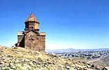
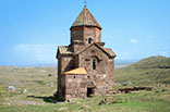
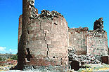
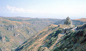
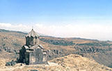
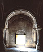
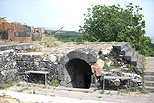
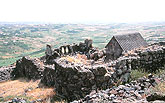
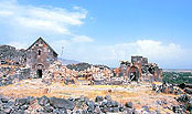
AMBERD ***
FORT & KATOGHIKE, 11c. **
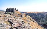 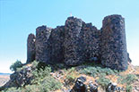
To the north of Byurakan continue mountain masses. Amberd located 7km northwest of the town of Byurakan is 2,300 meters above sea level, at the confluence of two rivers, Amberd and Arkashen, both of which are small but they and spread great gorges of magnificent views. On a peninsula above them emerge surrealistically the ruins of a castle from the 10th century and a completely restored church from the 11th century, standing over deep cliffs.
This is not a simple stronghold but a citadel including a fort, a castle and palaces. The most conspicuous structure is a fortress with many buttress towers in piling rough cut stones. It is a castle from the early middle ages, constructed in the same age as Krak des Chevaliers in Syria. Although the citadel was destroyed by Mongol army in 1236, it was restored by Vacuteans to use their residence. Bringing water from the mountain with clay pipes to underground cisterns, there was a domed bath house in the fort.
The citadel was abandoned in the 14th century, after which it has been left to fall into decay for seven centuries. Nevertheless, there are no other forts that survive with the skeleton of such a large fortress from the medieval period in
Armenia.
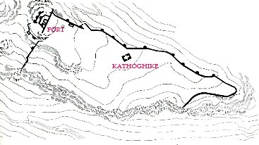 SITE PLAN of the Fort and Kathoghike of Amberd
(From "The Armenians" Adriano Alpago Novello, 1986, Rizzoli)
SITE PLAN of the Fort and Kathoghike of Amberd
(From "The Armenians" Adriano Alpago Novello, 1986, Rizzoli)
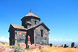
There might be a town in the citadel, forming a bishopric, so the Cathedral (Kathoghike) was erected. The inscription on the inside wall of the north tympanum states that it was built in 1026 by Prince Vahram (r. 967-1045) of the Pahlavid dynasty. This cruciform domed church has not the entrance on its west side but on the south side facade. It is made overall accurately of ashlars and relatively well kept, for it did not suffer war damage. Dilapidated umbrella-type roof was completely restored along with other parts between 1970 and 1976.
INDEX
TEGHER ***
TEGHER VANK, 1215 ***
The black color of stone is disadvantageous in appearance.
  Plan of Tegher Vank
(From "Architettura Armena" Paolo Cuneo, 1988, Deluca Editore)
Plan of Tegher Vank
(From "Architettura Armena" Paolo Cuneo, 1988, Deluca Editore)

INDEX
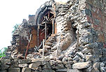
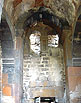
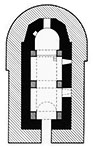
AGHTS (DZORAP) **
ARSHAKID KING'S MAUSOLEUM, 364
In the village of Aghts (former Dzorap) at the foot of Mt Aragats, just a little down off Tegher, there remains a hypogeum for Arshakid Kings. It must have been erected a mausoleum over this underground tomb chamber, none of which exists. The main room has an apse and two large arched niches on side walls with a stone panel, on which are early Armenian relief sculptures. Since this hypogeum was found in the 1970's, Toros Thoramanyan seems to have not known it.
Just on the northern adjacent high place of this are ruins of a three-naved basilical funeral church erected between the 4th and 6th centuries. It has lost almost all of the building, leaving only its bases. Its apse is horseshoe shaped in plan.
  Plan & the carved stone panel of the Mausoleum of Arshakid Kings, 364
(From "Architettura Armena" Paolo Cuneo, 1988, De Luca Editore)
(From "Early Christian Architecture or Armenia" Murad Hasratian, 2000)
Plan & the carved stone panel of the Mausoleum of Arshakid Kings, 364
(From "Architettura Armena" Paolo Cuneo, 1988, De Luca Editore)
(From "Early Christian Architecture or Armenia" Murad Hasratian, 2000)
INDEX
BYURAKAN **
SURP YOVHANNES, 10c. *
Byurakan is a town located 12km northwest of Ashtarak, embracing the church of Surp Yovhannes. It is a single-nave church erected in the 10th century by the Patriarch Yobhannes of Drasxanakert. Probably because of several times of repairing and reconstruction, its outer walls are layered in front and behind, ornamental ways of which are different to each other. There is ancient style blind arcade on the outer wall of the apse, looking older than 10th century. The entrance is not at the front side but at the side wall, surmounted with a horseshoe arch. This church gives an impression of a somewhat mysterious atmosphere. St. Yovhannes is St. John.
ARTAVAZIK, 7c. *
On the east of Byurakan, out of the town is a small church from the 7th century, called Artavazik. It looks as only a small frontal building, it had originally the main body of worship space behind, but it was destroyed by a flood in 1840. There stood a high belfry from the 13th century over the frontal facade when I first visited, but it has collapsed too due to a recent earthquake.
On the opposite side of a stream in the rear of the church is a grand Khachkar put in a curious building-like structure, standing in concert with the church. Both are made of reddish-brown stone.
INDEX
PARPI **
TSIRANAVOR CHURCH, 5c. *
The quirte old church called 'Tsiranavor', meaning apricot color.
 PLAN of the church 'Tsiranavor', 5c.
(From "Early Christian Architecture of Armenia" Murad Hasratian, 2000)
PLAN of the church 'Tsiranavor', 5c.
(From "Early Christian Architecture of Armenia" Murad Hasratian, 2000)
TARKMANCHAC, 7c. *
The church called 'Tarkmanchac' in the village of Parpi
SURP GRIGOR, 13c. *
The church of Surp Grigor in Parpi village
INDEX
APARAN
**
KASAGH BASILICA, 4c. *
On the outskirts of the town of Aparan, 50km north of Yerevan, is the Kasagh Basilica, which derives from the name of the Kasagh River flowing nearby. It is also called the church of Surp Khach (Holy Cross), one of the oldest Armenian basilical church, being supposed to have been first built at the end of the 4th century. It is a three-naved basilica with an apse, which was probably added in the latter half of the 5th century. Its plan is horseshoe-shaped, while its outside is five-hedral. The church's transverse arches and arcade's arches are also all horseshoe-shaped. Partly because its vaulted ceiling and roof were lost for a long time, the stones of exposed pillars were considerably weathered. Since the vault and roof were restored recently, the church has regained its original barn-like external appearance.
  ___ Q___________PLAN of Kasagh Basilica
( From "Early Christian Architecture of Armenia" Murad Hasratian, 2000 )
It has neither triangular niches on the outer walls nor rotunda-form belfry or skylight roofs, it is a simplest primordial Armenian church, having a few archaic decorations only around the portals and windows. The almost thoroughly ruined church was partly restored in 1877 and completely restored in the middle of the 20th century. On its northern side was later added a small chapel and a gallery.
INDEX
ZOVUNI **
SURP VARDAN, 5c. *
The church of Surp Vardan, Zovuni
SURP POGHOS-PETROS, 6c. *
Surp Poghos & Petros is St. Paul and Peter.
INDEX
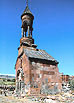
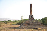
HARTAVAN **
TOMB TOWER *
A tomb tower (Matur) near Hartavan village
INDEX
ASTVATSENKAL **
SURP ASTVATSATSIN, 6c. *
The church of Surp Astvatsatsin at Astvatsenkal
INDEX
ARTASHAVAN **
SURP ASTVATSATSIN, 7c. *
The church of Surp Astvatsatsin in Artashavan, EC: Surp Amenaprkich
INDEX
SAGHMOSAVAN ***
SAGHMOSA VANK ***
Saghmosa Vank at Sagmosavan, with a library looking like a church
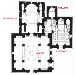 PLAN of Saghmosa Vank
(From "Armenian Art" Jean-Michel Thierry, 1987, Harry N. Abrams)
PLAN of Saghmosa Vank
(From "Armenian Art" Jean-Michel Thierry, 1987, Harry N. Abrams)
INDEX
USHI *
SURP SARKIS, 10-13c.*
The church of Surp Sarkis in Ushi
 PLAN of Surp Sakis at Ushi
(From "Architettura Armena" Paolo Cuneo, 1988, De Luca Editore)
PLAN of Surp Sakis at Ushi
(From "Architettura Armena" Paolo Cuneo, 1988, De Luca Editore)
INDEX
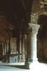
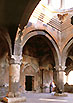
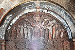
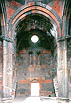
OHANAVAN ***
HOVHANNA VANK ***
Surp Yovhannes in the Hovhanna Vank in Ohanavan
photo of independent pillar in EC.383
An old church (Surp Karapet) pp.553-7
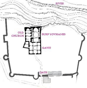 Plan of Hovhana Vank
(From "Architettura Armena" Paolo Cuneo, 1988, Deluca Editore)
Plan of Hovhana Vank
(From "Architettura Armena" Paolo Cuneo, 1988, Deluca Editore)
INDEX
MUGHNI **
MUGHNI VANK (Surp Gevorg), 17c. **
 __ __
The church of Surp Gevorg in the Mughni Vank from the 17th century
 Plan of Mughni Vank
(From "Architettura Armena" Paolo Cuneo, 1988, Deluca Editore)
Plan of Mughni Vank
(From "Architettura Armena" Paolo Cuneo, 1988, Deluca Editore)
INDEX
ASHTARAK **
BASILICA, 5c. or 6c. *
TSIRANAVOR (Surp Astvatsatsin)
Ashtarak is a small town with a population of less than twenty thousand, located 13 kilometers northwest of the capital Yerevan. It is a mild climate town 1,100 meters above sea level in the gorge of the Kasagh River. In spite of being small, its history is very old, said to have been one of the oldest settlements in Armenia, embracing many ancient churches and an arched bridge and a fort.
The half-ruined Basilica is the oldest church in Ashtarak, erected by the patriarch Nerses II (r. 548-557) who had been born here. It is a three-naved basilica with two rows of three columns partitioning the church into the central nave and side aisles, between which only one row survives, making an arcade. It is also supposed to have been constructed in two times as in the 5th century and the 6th century.
The church is also called 'TSIRANAVOR' (color of apricot) Church. This and next two churches are designated with names of colors because of a legend that tells that there were once three sisters in Ashtarak who fell in love with the same man, prince Sarkis, and throw themselves into the Kasagh River. Sarkis became a hermit and built three small churches for the three, so the churches came to be called by the colors of the three sisters' dresses. The Tsiranavor Church was for the eldest sister wearing an apricot color dress.
CRUCIFORM CHURCH, 6C. or 7c. *
KARMRAVOL (Surp Astvatsatsin)
 
This is a quite small single-room cruciform church, Surp Astvatsatsin, built in the 6th or 7th century. After the dress-color of the second eldest of the aforementioned three sisters, this is also called 'KARMRAVOR' (reddish) Church. Another theory is the name come from the color of its dome, though its roof tiles look like new, they are original.
It is the best-preserved church among the three, being a typical example of the small Armenian cruciform church of the early medieval period. Since its surroundings are cemetery, it could be a funeral church. Inside, the apse is covered with a half dome, while the other three arms are with semicylindrical vault on the square plan. The drum is octagonal, which is supported with squinches.
The third church is the Holy Mother of God (Surp Astvatsatsin) , also called 'SPITAKAVOR' iWhitish) Church. It is the church for the youngest sister of the legend, who wore a white dress when she was found out. The church might have been first erected in the 6th century and was rebuilt in the 13th century based on a square plan with an apse on the east. It might have possessed a domed tower, but the church was half destroyed by the earthquake in 1679.
SURP MARIANE, 13c. *
Surp Mariane is the largest church in Ashtarak, which was constructed as a part of a monastery in 1281 according to an inscription. There might have been a hostelry too. The long building attached to the church on its west side is an unfinished church. Was it intended to form a Latin cross church?
The high tower consists of an octagonal drum and extremely pointed conical roof, reminding us of Georgian churches. This must be the most slender church in Armenia. It is a mystery on its south facade that the entrance door lies largely toward left, while the window lies at the center.
SURP SARKIS *
This is a church built in 1986 in the 13th century style. As it stands on a hill facing a gorge of the Kasagh River, it can be seen from everywhere in Ashtarak, and one can get fine view of the town from here.
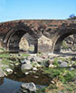
Under the gorge is a threefold-arched old bridge, which was constructed of precise cut stone in 1664 by a wealthy merchant, Mahdesi Khoja Grigor.
INDEX
OSHAKAN
SURP MASHTOTS, 19c. *
The church o Surp Mashtots in Oshakan, 1875-9
SURP SION, 7c. *
Mankanots from the 7th century, four-apsed Surp Sion across the river.
INDEX
|
.
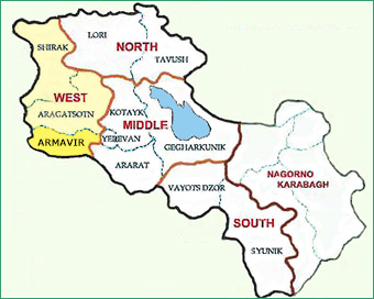
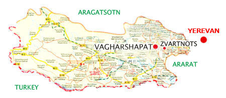
Armavir is the smallest province in Armenia, adjoining Turkey on its southern border. At Zvartnots, 11km from the capital Yerevan, is the sole international airport in Armenia. This province has the most important sacred town, Vagharshapat, key to understanding early Armenian architecture, since it holds many ancient churches. However, there are hardly any other noteworthy monuments. The provincial capital is Armavir.
INDEX
VAGHARSHAPAT ***
Next to the Artaxiad (Artashesian) dynasty, the second ruling dynasty of ancient Armenia was the Arsacids (Arshakuni) continuing from 66 C.E. to 428 C.E. King Vagharsh I (r. 117-144) constructed a new city as his capital, so it was called Vagharshapat after his name. Later in this city was erected the Cathedral for the Katholikos (Patriarch), the church of Surp Echmiadzin, and the city became the religious center of Armenia. Although the city was officially renamed Echmiadzin between 1945 and 1995 in the age of the Soviet Union, it has been put back to Vagarshapat.

Map of Vagharshapat (from Google Maps)
The Cathedral of Surp Echmiadzin, the Churches of Surp Hripsime, and Surp Gayane were inscribed on the UNESCO World Heritage in 2000, together with the Cathedral at Zvartnots. For those churches,
see the chapter 1 "Surp Echmiadzin and other Vanks in
Vagharshapat". |
SURP SHOGHAKAT, 1694 *
 
This is a church near St. Hripsime in Vagharshpat, built by Prince Aghamal Shorotetsi in the 17th century. The place seems to have been ruins of some martyr from the 7th century. Being a single nave church without any columns, its depth is 2.5 times long as its frontage. At its center is a tall dome surmounted with twelve angled drum and conical roof. The apse has a small sacristy on both sides, making the overall plan a complete rectangle. The spectacular feature is the elaborate geometric carved patterns on the porch's walls.
Like Chhatris in India, bell tower on a porch became a symbol of Armenian church, being always built, here too.
SURP ASTVATSATSIN, 19c.
The original church was made of wood in 1767. It was reconstructed in the 17th century of stone. It has a Rococo style alter. The bell tower constructed in 1982 has large arched openings, through which the other side sky can be seen.
|
BACK NEXT

© TAKEO KAMIYA
E-mail to: kamiya@t.email.ne.jp
|