CHAPTER 4
ARCHTECTURE in
MIDDLE ARMENIA
TAKEO KAMIYA

BACK      NEXT

.
Map of Kotayk
KOTAYK PROVINCE

Middle Armenia consists of the capital area of Yerevan and three provinces: Kotayk, Ararat and Gegharkunik. Kotayk province in the northwest embraces a principal trunk road from the capital to Georgia through Sevan. The provincial capital is Hrazdan in the north. The Geghard Vank and Garni Temple are near the border with Ararat province in the south.


Map of Kotayk Province


INDEX


TZAGHKADZOR **

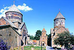
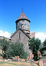
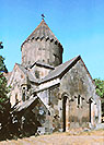
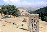
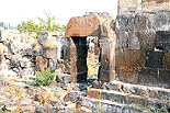
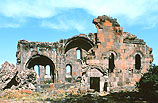
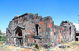
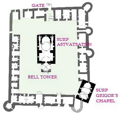
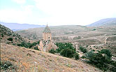
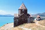
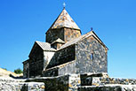
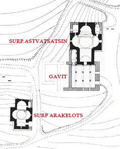
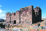
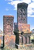
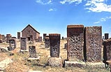
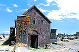
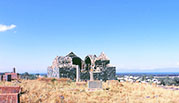
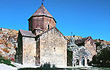
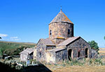
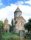
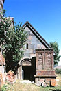
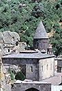
KECHARIS VANK, 11-13c. ***

KecharisKecharis

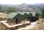
The name 'Kecharis' derives from the former name of the town of Tzaghkadzor, Kecharyuk, a famous ski resort 4 km west of Hrazdan, 1,840m above sea level. It was renamed Tzaghkadzor in 1947. The vank (monastery) was established in the upper district of the town by a Pahlavid magistrate in the 11th century. The construction continued intermittently up to the middle of the 13th century. Kecharis Vank was one of the most important cultural and educational centers in Armenia in the 12th and 13th centuries.

The monastery suffered severe damage by an earthquake in 1827, collapsing the tower-part structures of the two main churches. They had remained in those states for a long time, more than a century and a half. The reconstruction started in the 1980s but was interrupted for about 10 years due to the breakdown of the Soviet Union and the outbreak of the Nagorno Karabagh War. It resumed in 1998 and finally completed in 2000, letting the monastery regain the beauty of its perfect architectural ensemble. It is said that an Armenian Vladimir Harutyunian from Vienna contributed.

PortalKecharis

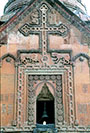
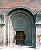
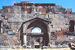
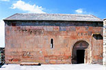
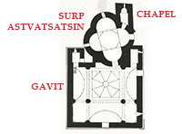
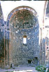
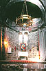
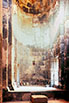
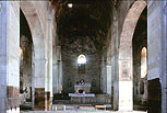
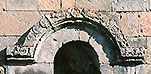
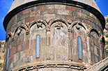
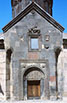
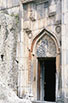
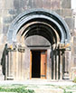
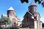
The first building of the monastery is the main church of Surp Grigor Lusavorich erected in 1033 by Prince Grigor Magistros (990-1059), a Pahlavid theologian and the son of Prince Vasak of Bjni. There are some other views of its construction date like 1003 or 1013. It is a hall-type domed church with two-storied small chapels on both sides of the apse. On the southern side wall is a magnificent portal, on the tympanum of which is not figurative relief sculpture but only an inscription. Its dome and drum with a conical roof had been lost by an earthquake in 1827 and left as it were so long time, but they were reconstructed by 2000.

Plan
PLAN of Kecharis Monastery
(From "Armenian Art" Jean-Michel Thierry, 1987, Harry N. Abrams)

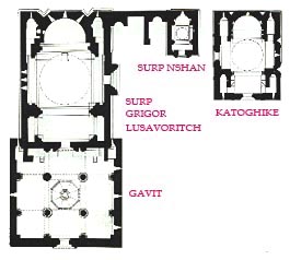
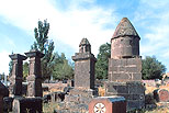
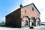
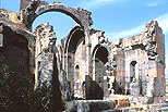
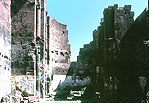
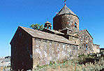
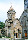
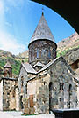
The smallest church in the monastery is the church of Surp Nshan(Holy Seal), also called Surp Khach (Holy Cross), erected in 1051 in the wake of the Surp Grigor, dedicated by Prince Grigor Magistros too. It is so slender that such a extremely vertical church can rarely be seen in Europe. It is impressive that its long drum is ornamented with six-facet continuous arcature with an oculus.

The southernmost church is the Katoghike (Cathedral) constructed by Prince Vasak Khahbakian of the Proshian family in the early 13th century, during 1203 to 1214, based on the architect Betsik's design. It has an almost the same plan as the Surp Grigor, but the main entrance portal is on its western side. Its four-folded arches are infrequently pointed and horseshoe. The Katoghike also suffered collapsing its tower part by the 1827 earthquake, but it was reconstructed in 2000. Its drum has a graceful decoration with twelve continuous blind arches on slender twin semi columns.

OrnamentsNshanKecharis

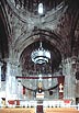
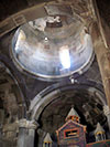
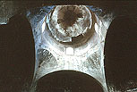
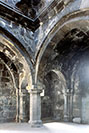
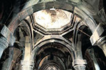
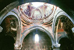
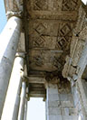
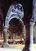
The Gavit was built in 1206 based on a typical plan with four central independent columns, with four two-story vestries at its east both corners for the first time for a gavit. The columhs are all monolithic. The central bay forms an octahedral cloister vault-like Yerdik like the gavit of the Gosha Vank from the same age, with a skylight on the top. Outside, over the central window of its southern wall are carved lovely relief decorations and a sundial.
After the devastation of the monastery by Mongolian invasions in the 1230s, it was restored by Prince Hasan of Khachen in 1248. presumably in that year frescoed a 'Deisis' on the tympanum of the portal to the church of Surp Grigor from the Gavit.

GavitTimpanum

Between the Surp Grigor and Surp Nshan were two oldest chapels and a central hall, which have been almost all lost. A line of khachkars is set on the wall of the hall now.
There are also many khachkars at the rear of the churches, among which the largest is called the 'Khachkar of Vetsik', who was the main architect of the Kecharis Vank.

KhachkarsKhachkar


SUROP ARTYUN (Holy Resurrection), 1220 *

KecharisKecharis

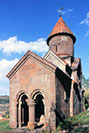
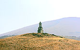
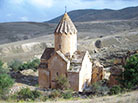
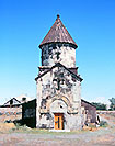
On a wooded hill about 100 meters opposite the Kecharis Vank is an independent small church from the 13th century. It was erected by the son of Hassan in 1220. It appears to have been a funeral chapel of the founder of the Katoghike, Prince Vasak of the Proshian family.
It has a tall drum and a dome surmounted with a conical roof, moreover has an unusual closed porch (gavit?) in front, making the length of the church quite larger.

INDEX


HRAZDAN *

MAKRA VANK (Surp Astvatsatsin), 10, 13c. *

HrazdanHrazdan

Hrazdan was a planned industrial city in the age of USSR, located 45km north of Yerevan. At the Makravan district in the old city was the Makra Vank (Monastery) , of which leaves the church of Surp Astvatsatsin (Holy Mother of God) from the 13th century and an older chapel of Holy Redeemer on its side, built in the 10th century (also said in the 11th). The roof of the dome is conical and the chapel is covered with a gable roof.

HrazdanHrazdan

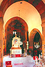
There was once a gavit in front of the Church of Surp Astvatsatsin and behind the church was a graveyard where many khachkars still remain. Inside the semicircular apse of the church is a painted wooden iconostasis uncommonly in Armenia.

INDEX


BJNI **

SURP ASTVATSATSIN, 1031 *

BjniBjni

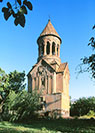
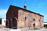
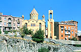
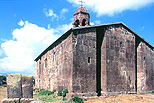
Bjni is a village located 12km southeast of Hrazdan. There retains the large church of Surp Astvatsatsin (Holy Mother) from the early 14th century at the foot of a mountain. It is a hall-type church with an umbrella roof of multitudinous folds on the high drum. The plan is a complete rectangle with two triangle niches on both sides of the apse, making a formative west facade along with a central window. The church was improved in 1647, when the roof was probably made steep. The church was overall repaired in 1947.
In its precincts are many old khachkars. Inside the church are interestingly designed capitals of clustered columns supporting the transverse arch of the apse.

Bjni


SURP SARGIS, 7c. *

BjniBjni

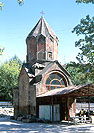
Surp Sargis Church stands symbolically on a hill a little southeast of the church of Surp Astvatsatsin. It is supposed to have been erected in the 7th century and being the smallest church with a cruciform plan in Armenia. Its dome is surmounted with an octagonal pyramidal roof, but the church thoroughly lacks decoration. It was repaired in 1970. Surp Sargis is the martyr St. Sergius.


INDEX


ARZAKAN **

NEGUCHI VANK, 11-13c. *

Arzakan

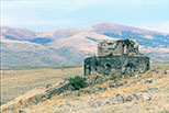
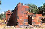
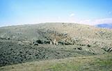
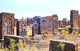
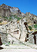
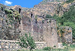
The ruined vank of Neguchi on the mountain

ArzakanArzakan


INDEX


ZORAVAN **

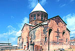
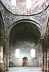
ZORAVAR (Surp Teodoros), 661-685 *

ZoravanZoravan

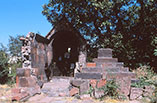
The eight-apse round church at Zoravan.

Plan
PLAN of the Zoravar Vank
(From "Architettura Armena" Paolo Cuneo, 1988, Deluca Editore)


INDEX


YEGHVARD **

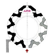
SURP ASTVATSATSIN 14c. ***

YeghvardYeghvard

Yeghvard, literally meaning 'fragrance of rose', is a small town only 18km north of the capital Yerevan. Its origin might be one of the oldest settlements in Armenia. It embraces many historical buildings, but most of them have become ruins.
According to the inscription on the entrance doorway, the church of Surp Astvatsatsin was constructed in 1301 by Prince Azizbek of the Zakarid dynasty (1201-1360), while the writing on the dome say that the church was built from 1318 to 1328.

Although it has the same form in the architectural composition as the church of the same name and same age in the Nora Vank near Amaghu, it is a little smaller and slender. It looks like a 3-story building, but actually being 2-story with a top rotunda, the floor of which does not exist but is the upper space of the second-floor chapel. The rotunda has 16 columns as the Amaghu, and also the same style cantilevered flight of stairs from both sides as at the Amaghu, but that at Yeghvard fell down, leaving only the top landing. Conversely, it has steps down to the ground floor entrance, which is now like a semibasement as the land has been upheaved. The rotund was reconstructed in 1970.

YeghvardYeghvard

Four-side walls of Surp Astvatsatsin are all elaborately ornamented with reliefs and are well preserved. Their motifs are mainly geometrical patterns, adding bull, lion, eagle, and the Holy Mother of God and the Child on the top of the west wall. The interior of the ground floor is dark without a window. The altar in the apse is heightened with steps on both sides. ( PC.51, AA.521, MH.210 )
Not far from Yeghvard is one more church of the same form at Kaputan, though smaller and less ornamented.


BASILICA, 7c.

YeghvardYeghvard

Near the church of Surp Astvatsatsin in Yeghvard is the ruins of a basilica from the early medieval period. From its architectural style, it is considered to have been erected in the 7th century, but another view is that it was the Katoghike (Cathedral) from the 5th century. The most part of the basilica was destroyed during the Ottoman-Persian War in 1730-35.
The excavation of the early 20th century revealed its plan. It was a three naved basilica with a protruding apse, semicircular inside and pentagonal outside.
There is an extensive Gerezmanots (graveyard) behind the basilica, holding many khachkars (Cross Stones) from the 11th to 14th centuries and various shaped tombstones. There are also the ruins of a single-naved church from the 5th or 6th century in the city.

INDEX


KAPUTAN **

KAPTA VANK (Surp Minas), 1349, *

KaputanKaputan

A church of the same style of that of Yeghvard stands in isolation on a hill.


INDEX


KANAKERAVAN *

SURP HAKOB 1695 *

KanakeravanKanakeravan

On the northern suburb of Yerevan is the church of Surp Hakob in the town of Kanakeravan, former Kanaker village, built at the end of the 17th century according to an inscription. As it is a three-naved basilica without a dome, a conical roof, and even V-shaped niches on the walls, it looks architecturally a little too simple church. Such a rectangular parallelepiped covered with a saddle roof can be said to be near a barn of a farm. It is the most primordial form of Armenian church.

Plan   Kanakeravan
          PLAN of the church of Surp Hakob
   (From "Architettura Armena" Paolo Cuneo, 1988, De Luca Editore)

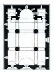
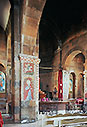
What make us notice it to be a church are a small rotunda-style roof for the central skylight and the extremely decorative facade with three continuous arches. The central many-folded arches are geometrically ornamented with frets and muqarnas in the same style as at the portal of the 17th century church of the Mughni Vank. However, the front portico's columns and roof have been lost here at Kanakeravan. Inside, many murals were painted but are not much harmonized with the building. Surp Hakob is St. James. When I visited, it was under construction of a wall at the front.


SURP ASTVATSATSIN, 17c. **

KanakeravanKanakeravan

On a nearby small hill in the town of Kanakeravan is another church, Surp Astvatsatsin from the same 17th century as Surp Hacob, but probably slightly earlier. They are sister churches, resembling very much each other in scale, form, and plan.
The rich ornamentation around its entrance portal is in the same style as in those on Surp Hacob and the church of the Mughni Vank, but here the gable wall over it is conspicuous by its checkered pattern with black and red color stones, while on its southern facade is a horizontal striped pattern with the same color stones. Interior of the church has almost no decorations. On the roof is a small rotunda over a central skylight, elaborately carved up to the six columns, two-tier arches, and their capitals. A belfry miht have been erected on the lost portico.

KanakeravanKanakeravan


KHACHKAR SHRINE, 1265 *

KanakeravanKanakeravan

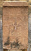
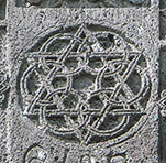
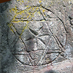
In the town of Kanakeravan is a Khachkar (Cross Stone) uncommonly made like a building with a gabled roof. An inscription says that it was erected in 1265 by order of Petewan and his wife Awag, worked by a sculptor named Mhitar. Human figures are rarely incorporated into the khachkar, probably being the husband and wife and their family. There are many 17th century khachkars around it.


INDEX


PTGHNI *

KATOGHIKE (Ptgha Vank), 6c. *

PtghniPtghni

The ruins of a huge Katoghike (Ptgha Vank) on a hill viewing the Hrazdan River. Since it resembles Surp Gregory in Arutch, it is supposed to have been built in the 6th or 7th century.

Plan    Ptghni
          PLAN of the Ptghni Katoghike
 (From "Architettura Armena" Paolo Cuneo, 1988, De Luca Editore)


INDEX


GARNI ***

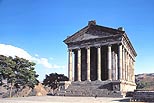
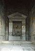
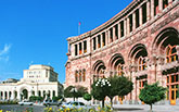
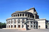
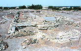
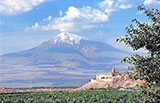
ROMAN TEMPLE, 77A.D. **

GarniGarni

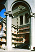
Though there might be someone who feels the existence of a Hellenistic Roman temple unsuitable for Armenia, this is a reconstructed building in the 20th century as a matter of course. It was first built in the 1st century far earlier than the Christianization of Armenia. The tradition says that it was constructed by a sister of Trdat I (r. 66-88), the first king of the Arshak dynasty (66-248), in 77 A.D. and consecrated to Helios, the god of the Sun. This is a typical peripteros (surrounded by a portico with columns) -type temple, standing on a podium with 9 steps high.

GarniGarni

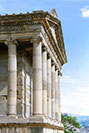
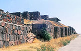
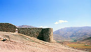
The promontory surrounded by the Azat river's deep canyons for its three sides as a impregnable sacred precincts and its fourth side (west) was built ramparts with 14 rectangular towers and a gate. After the conversion to Christianity of the royal family, a palace was erected on the west of the temple as their summer imperial villa.
The temple was broken down in 1638 by Ottoman army and was completely destroyed by an earthquake in 1679. Long afterward in the 20th century, this temple site near Garni village was extensively excavated and the temple was restored to the original form using as much as unearthed components of granite during 1969 and 1975. It is now a perfect peripteros-type Roman temple.


BATHS, 3c. & SURP SION, 659

Garni

There are ruins of 3rd century Roman style bathhouse 50 meters west of the temple. It is not clear if it belonged to the temple or Arshakid palace. It consists of four rooms: a caldarium (hot room), a tepidarium (warm room), a frigidarium (cold room) and a hall. It was under repair, covered by a temporary roof and with a provisional passage inside when I visited, making it impossible to take photos of mosaics.

GarniPlan
________ PLAN of Surp Sion
      (From "The Armenians" by Adriano Alpago Novello, 1986)

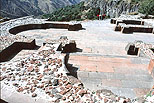
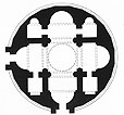
During the period of Byzantine Empire ruling Armenia (631-693), right next to the temple was constructed the round shape church of Surp Sion by the patriarch Nerses III in 659. As its diameter is about 20 meters, its scale is quite large. Its composition is curious as the four-apse plan is not packed in a square wall but in a circular wall. To put it accurately its outer shape is not circular but 24-agonal. A similar round church was in Marmashen in a smaller scale, but both have lost their superstructures, so one can see here only its excavated foundations.


SINGLE-NAVED CHURCH, 5c. &
MASHTOTS HAYRAPET CHURCH, 1274 *

Garni

Apart from the temple site, nearby Garni village itself holds several churches and ruins. The oldest one is the ruins of a single-naved church from the 5th century. It is a large basilica-type church embracing four bays and a deep semi-circular apse. It had a colonnade with a doorway to the church on its south side like the Yereruk Basilica at Anipenza.

GarniGarni

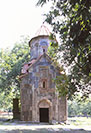
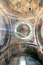
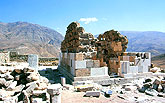
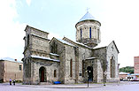
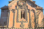
Although Mashtots Hayrapet Church from the 13th century is a small single bay church, its four facades and the drum are very elaborately ornamented with reliefs. When catching the sun, there is a clear contrast between the light gray stone walls and red tuff roofs. Hayrapet is Patriarch. A small Khachkar shrine stands by the side.

INDEX


GEGHARD ***

GEGHARDA VANK 12- 13 c. ***

Gegard

A representative work of Armenian architecture, along with the Haghpat Monastery, is the Gegharda Vank (the Monastery of the Holy Spear) in the Province of Kotayk in middle Armenia. It forms an ensemble of monastic facilities, whick is histsorically and artistically very important and attractive. The monastery is still active today, like the Haghpat Vank, and was inscribed in the UNESCO World Heritage List in 2000. Its registration name 'Monastery of Geghard and the Upper Azat Valley' sounds a little strange, but it probably intends to also make the sublime landscape of the valley around the monastety, as seen in the above photo, as the seamless object for conservation.

Gegharda Vank (Monastery of the Holy Spear)

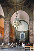
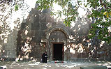
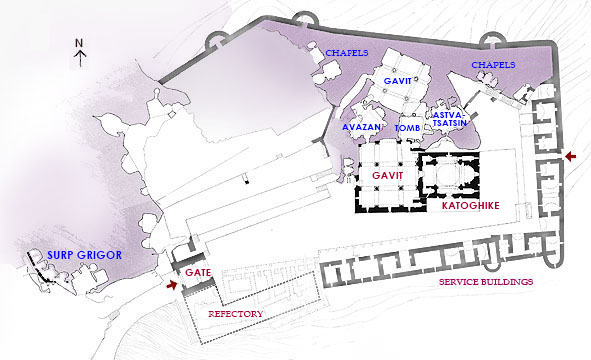
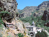
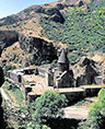
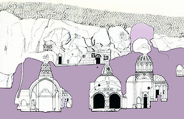
Gegharda Vank had been called 'Ayri Vank' (Monastery of the Cave) before. As the name signifies, it mainly consisted of many cave dwellings and cave chaplels excavated in rock mountains here. Ancient Armenia and Georgia had numerous cave churches and dwellings like in India, leaving now a lot in Georgia but a few in Armenia. Here in Geghard is a group of the best cave churches, which was unified with the 13th century stone Cathedral into a unique monasatery without an equal.

Site Plan
____________ SITE PLAN of Geghard Monastery (purple parts are natural rocks)
_______________ On the left hand outside the gate is the oldest church of Surp Grigor
__________ (From "Documenti di Architettura Armena 6. G(h)eghard" 1978)

Geghard Monastery is said to have been established by Surp Grigor Lusavorich (St. Gregory the Illuminator) in the 4th century in rebuilding an exisiting pagan temple into a Christian church. The early buildings were destroyed in the 10th century by the Arab army and in the 12th century by the Seljuks. Only the church of Surp Aatvatsatsin (current Surp Grigor) from the 12th century was saved from destruction, but all other older buildings were annihilataed.
It was in the 13th century that the monastery revived. After it became under the protection of the Zakarian family, the stone Katoghike was completed in 1215, so that the Vank was reestablished. The Atabek of the Seljuk dynasty, Ivanê Zakarian turned over the monastery to his vassal, Prince Khaghbakian Prosh of the Proshian family.
Prince Prosh enlarged the precincts of the Vank and resumed the construction, excavating cave churches. The combination of the stone Catoghike and cave churches created a rare kind of monastery. It became an important educational and cultural center of Armenia within the 13th century, taking rank with the monasteries of Haghpat and Tatev.

GeghardGeghard

’Geghard' means the spearhead that stabbed Christ on the Cross, which exist at some places in the world. Since one of them was brought here in the 13th century, the monastery came to be called 'Gegharda Vank' (Monatery of the Holy Spear). A legend says that a Roman soldier named Longinus pierced the right side of Jesus with this lance to make sure his death. The spear was enshrined in the Katoghike Church, but now is exhibited in the treasury museum of Surp Echmiadzin in Vagharshapat.

The Church of Surp Grigor (former Surp Astvatsatsin)

Gegharda Vank soars high from the front road level, as if being a fortified monastery retained by ramparts with round towers, the state of which was after the main church built of stone in the 13th century became the Cathedral of this area. Before that, the monastery largely consisted of chapels dug in the natural rock mountains and cave dwelings for monks along with rock carved numerous khachkars. It is the 12th century church of Surp Grigor (previously Surp Astvatsatsin) that informs us those earlier forms of the monastery.

Grigor

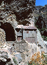
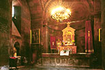
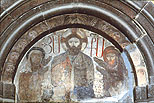
It was built on the cliff on the west of the current monastry precincts, outside the main gate. It is the oldest existing church, forming half cave and half stone building. At the first beginning, it might be a simple chapel utilizing a natural cave, then adding stone walls on its one side and a roof, so as to give it an architectural feature. On its plain outer walls and circumferential rock surface are carved many khachkars, it makes an uncommonly charming facade. Inside is an irregular cave chapel with a semicircular apse, which has a vestige of a fresco depicting the Virgin and Child.
Since it is the first church in the monastery for people coming from Yerevan to encounter, and is the oldest existing church, and is an architectural piece of a cave mixed together with stone piling parts, Surp Grigor can be said being the symbolic church of Geghard Monastery.

Ayri Vank (Monastery of the Cave)

The old name of Gegharda Vank (Monastery of the Holy Spear) was Ayri Vank (Monastery of the Cave). Monks originally used natural caves for dwelling and worship, and gradually excavated artificial cave chapels on the rock mountains here. Among existing four fine cave works, the first excavated was the "Church of Avazan" (Church of the Fountain) in about 1240. The name of the architect , Galdzag, is carved at a lower spot of the dome.

Avazan

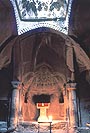
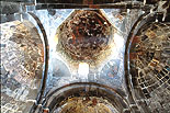
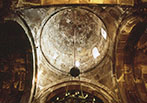
It was excavated as a complete iminatation of a true structural system like Indian cave temples, sculpting four pairs of crossed arches spanning from a pilaster to a pilaster. The central bay forms a Yerdik, the top of which is a real skylight. The Yerdik and the half dome of the apse are ornamented with stone carved muqarnas influenced by Islamic architecture.
There is a fountain (avazan) at the north end of the church. The exsistence of this fountain could have been the original reason for the foundation of Ayri Vank. This gushing fountain seems to have been regarded as sacred from heathen days before the advent of Christianity to Armenia. The place must have been a natural cave with a fountain.

Plan
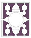
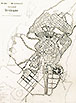
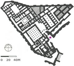
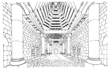
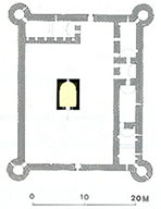
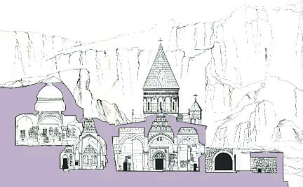
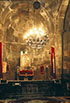
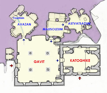
PLAN of the Caves and Katoghike of Geghard Monastery
(Purple parts are natural rocks and gray parts stone piled walls.)
(From "Architectural Ensembles of Armenia" O. Kh. Khalpakhchian, 1980)

The next "Mausoleum of the Proshian Family" was created in 1283. It would have also functioned as a gavit for the church of Surp Astvatsatsin. Since it is not a church itself, it took a unique space composition. When entering this excavated hall from Gavit, one faces a central strong column and two arches spreading on its both sides.

Proshian

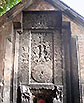
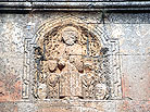
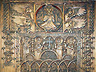
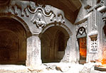
On the wall over the arches are very impressive large relief sculptues in humorous expression. They are two lions linked with a chain and an eagle holding a lamb by his claws. They might be symbols of the Proshian family. The interior space behind the column and arches was the Arcosolium for Prince Prosh, completed by his son, Papak.

Section
Cross Section of the Cave part of Geghard Monastery
From the left, Church of Avazan (1240), Mausoleum of the
Proshian Family
(1283), Church of Surp Astvatsatsin (1283).
At one story higher and deeper place is Upper Gavit (1288).
(From "Documenti di Architettura Armena 6. G(h)eghard")

The cave behind the mausoleum, the "Church of Surp Astvatsatsin", was completed in 1283 by the donation of Prince Prosh as is carved on its northern wall. In order to excavate this cave, and to carry out the smashed rocks too, the neighboring cave of mausoleum had to be excavated in advance. As is not thought that they were excavated within one year, the two caves needed some years and were completed in the same year of 1283. These two are supposed to have been also created by the same archtect Galdzag as for the Church of Avazan.

Astvatsatsin

The cave church of Surp Astvatsatsin, supposed to have been the fureral chapel of the Proshian Family, was excavated just like a real stone church on the ground, representing the pilasters, arches, pendentives, drum and dome. On the dome surface are sculpted twelve life trees, and the ornamentation with blind arcades on the drum resembles that of the outside of the Katoghike's drum.

The "Upper Gavit" was excavated last of all, during the reign of Prince Papak, the son of Prosh. It is at the level one story above the other three caves and on a much larger scale (see the Site plan). It is inscrived on one of the four center columns that it was created in 1288 by Papak and his wife Ruzukan, so this is also called Papak and Ruzukan's Gavit. This was completed much later than the "Lower Gavit" in isolation without direct relation with any church, and has to be approached through a long tunnel. What was the purpose of this Gavit?

Upper GavitUpper Gavit

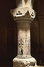
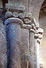
This gavit has a regular form of the square plan with four freestanding cental columns, from which spread arches to four directions, dividing the room into nine bays, the center of which forms a Yerdik with a true skylight on top. The four realistic columns have capitals with corner nitches of muqarnas carvings and their shafts are full of insdriptions and crosses.
Is it a mistake of the estimation of its floor level?, the southern corner of the floor of the gavit pierced the corner ceiling of the just below cave of Proshians' Mausoleum. Through this small hole, one can peep into the below hall.

The Church of Katoghike (Cathedral)
Section
Cross Section of Geghard Monastery
On the left hand is Upper Gavit and Church of Avazan,
on the right hand Gavit of the Katoghike and Service Buildings.
(From "Documenti di Architettura Armena 6. G(h)eghard" 1978)

The Katoghike (Cathedral) Church of Geghard was constructed in 1215 by the brothers Zakarê and Iwanê of the Zakarian family, as inscribed on the western entance portal. It is a standard type Armenian church on a rectangular plan with a central dome crowned with a conical roof with two-storied small chapels or sacristies in four corners. Ornamented with ample relief sculptures on its drum and external walls, it is not too much to say that it is a representative work of maturest Armenian church architecture. Although it has been in fair preservation overall, only its roofs were all covered with metal plates during the 20th century. It regained its original dignified appearance by restoration with stone in 1980.

KatoghikeKatoghike

As I wrote before, an Armenian church has usually an exact rectangularly outlined plan with a few small triangular niches, suggesting a simple cuboid building on the ground, but actually it creates a very complex three-dimentional sculptural figure of edifice, provokinfg a magical feeling on me. The principle of its composition is the multilayered combination of geometric solids like a cone, a cylinder, triangular gabled roofs, vertical triangular niches, and so on. My impression of Armenian architecture as the 'archetype of architecture' could have occured from such a primordial principle.

What I could not easily understand the role of among its architectural components was the small corner triangular roofs protruding diagonally at lower part of the drum (see the above photo of the Katoghike). It is surely one of the elements that make the architectural figure of the church more compound and animated. They always exist even at an octagonal drum, at four corners.

KatoghikeKatoghike

In order to build a dome over a square hall, it has to be supported by 'squinches' (corner arches) or 'pendentives' (curved spandrel walls). Armenian archirtecture uses both squinch (tromp in French) and pendentive (pendentif in French). At Armenian and Georgean churches, under domes are high drums (tambours in French) of the same diameters, which have windows for lighting. The drum of the Katoghike of Geghard is set on pendentives, while that of Odzun on squinches. Then those pendentives and squinches protrude from the drums, so those parts need small independent roofs on four corners of the drums. Thus Armenian churches become more compricated in its superstructure.

KatoghikeKatoghike

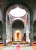
The outer wall of the cylindrical drum of the Geghard Katoghike is quite ornamental, divided with paired small columns and blind arcade into 16 faces, which are decorated with reliefs of birds, animals, and medallions. the church has also a splendid entrance porrtal in its southern facade apart from the western one. It has a grand arch, above which are reliefs of two doves and the timpanum of which is fully carved with pomegranates and grapes. Under the gable is a relief of a lion attacking an oxe And some khachkars.

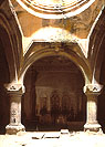
The Gavit on the west of Katoghike is supposed to have been built between 1215 and 1225. As seen in the photo it was made in a large simple square form in contrast to the church of Katoghike. Its roof is near flat also in contrast except for the one step higher part of the Yerdik with a small rotunda roof over the skylight. The outer walls of the Gavit are also almost flat except around windows.
The western entrance portal of the Gavit is a little deviated to the south from the central axis due to the rock in front. Its timpanum is sculpted in a dancing-likde form of creepers.

GavitGavit

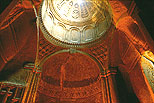
Interior of the Gavit is magnificent with four central columns and arches dividing the ceiling into nine bays as usual, the central one of which is a Yerdic decorated with fine stone piling muqarnas overall with a skylight on top. Such a minute muqarns ceiling of a gavit is the earliest example.
The Gavit's northern wall is natural rock flattened with chisels, having two doorways, one to the cave church of Avazan, the other to the mausolum of the Proshian family. The scale and location of the Gavit must have been desided to meet those demands.

Precincts of the Monastery

Rock mt.Ramparts

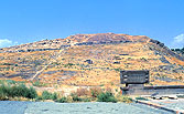
The site of the Geghard monastery was slant to the south, so its precincts were flattened by cutting and heaping up earth and surrounded by rock mountains on the north-side and by ramparts with round towerws on the east an south-sides. As a result it has risen quite high from the front road level like a fortress.
Inside along the eastrn and southern ramparts were erected service buildings in a row like offices, a refectory, and abbot's dweling in the 17th century, but they were reconstructed many times, leaving no original buildings.
There are large khachkars at many spots in the precincts and also numerous khachkars are carved on the rocks. Small cave chapels were excavated in the rear rock mountains. There is a fountain house outside the precincts for the use of everyone.


INDEX

.

Map of Yerevan
YEREVAN, CAPITAL

The administrative division of Armenia is composed of ten provinces and the capital Yerevan, which is not so enormous, having a population of about 1,100,000. Although the first record of the name Yerevan was in 607, it was a very small city during the medieval period. It developed more or less in the 15th century, but was destroyed by surrounding countries' invasions and earthquakes, leaving few antique buildings.
In the early 20th century made up the Armenian architect, Alexandr Tamanian (1878-1936), the city planning of the large new Yerevan over the small old Yerevan. Since it was in 1918 that Yerevan became the capital of Armenia and Tamanian's plan was authorized in 1924, it can be said that current Yerevan is a 20th century's new city, while its origin was very old, embracing the ruins of a medieval cathedral in Avan (Awan) on the northern outskirts of Yerevan, and the ruins of ancient city of Erebuni, from which the name of Yerevan derived, in the southern suburbs of Yerevan. Calculating from the establishment of Erebuni, the history of Yerevan has elapsed 2,800 years.

INDEX


AVAN (AWAN) *

KATOGHIKE (Cathedral), 591 *

AvanAvan

At Avan on the northeastern outskirts of Yerevan is the ruins of the Katoghike (Cathedral) on the place of the erstwhile Patriarchate since the 6th century. It is not in a small scale, outlined about in 15m by 20m. It severely suffered in the earthquake in 1679, losing its roof and most part of its inside.
Although its four-apse plan is descended from the church of Surp Hripsime in Vagharshapat, Avan's every corner room and its front room remarkably has a round shape, also considered as the oldest example of five-dome type. Such feature cannot be noticed from the outside at all, though.
The western facade is comparatively well preserved. Its central entrance with round columns on both sides is capped with triple arches and a shallow gable roof, looking monumental, and reminding us of the portals of the Yereruk Basilica in Anipenza.

PlanAvan
____________PLAN of the Cathedral of Avan
 (From "Early Christian Architecture of Armenia" Murad Hasratian, 2000)


SURP HOVHANNES, 5c. *

AvanAvan

A single room type small church of Surp Hovhannes is left in half destroyed state near the Katoghike at Avan. Surp Yovhannes is St. John. Its wall of reddish-brown color stone are very impressive. On the lintel is carved a cross, and on the left of the church stands stately a Khachkar from the year 1297 with a gabled roof. The circumference of this church was a cemetery, still embracing a smaller church of Surp Astvatsatsin and independent pillars. ( PC.8, AA.501, EC.184, MH.68 )


INDEX


.
YEREVAN ***

The city of Yerevan, which Armenian architect Alexandr Tamanian planned, extends largely to the north and south. Its very central zone based on the former small town has a few old buildings, regarded now as an 'old city'. Since Tamanian encircled that zone with a circular green belt, Yerevan has got an image of a round city regardless of its rather grid pattern inside of the circle.
Despite of being a new city, many traditional style sone faced buildings stand in the central zone, giving a medieval appearance. Outside of the hills surrounding the central zone are industrial districts and housing areas developing due to the gravitation of the population into the capital, with Soviet-style high-rise and medium-rise apartment buildings.
Recently a new commercial linear district has been redeveloped in the heart of the city, between the Opera and the National museum, erecting many new buildings with traditional tastes.

Map


CITY PLANNING & A. TAMANIAN, 20c. **

YerevanYerevan

The master plan of Yerevan was drawn by Alexandr Tamanian in 1924, encircling the existing small town with a circular green belt as the city's central zone. Holding the existing road pattern, he created the Republic Square (former Lenin Square) and the Liberty Square (Opera Square) as the nucleus of the city.
The green belt, which can be estimated as Tamanian's greatest achievement, is still places of recreation and relaxation for citizens. About a half of its area is operated as wooded cafe-terraces, where people sip beer spending long time, hearing bids' twittering, reading a book, or chatting with friends, that is the citizens' custom.

This central zone is now the 'old city' of Yerevan, outside of which spread broad housing estates. The city's rapid sprawl was far beyond Tamanian's forecast, growing to a large city with a population of 1.1 million nowadays. It is this 'old town' that tourists visit and modernization with commercial redevelopment is proceeding.

Plan
The City Plan of Yerevan by Tamanian
(Courtesy of the Tamanian Museum, Yerevan)

TamanianTamanian

The park-like boulevard for pedestrian under the Cascade is named 'Tamanian Street', near the entrance of which is a Alexandr Tamanian's statue sculpted by Artashes Hovsepyan in 1974.
In the Government Building next to the Republic Square is the Tamanian Architecture-Museum, exhibiting his photos, drawings, models of his works, and other materials. Recently its exhibits have been fairly enriched, also functioning as a museum for the architectural history of Armenia.


TAMANIAN'S WORKS, 20c. *

TamanianTamanian

Alexandr Tamanian (1878-1936) was born in Yekaterinodar (now Krasnodar) , Russia, and was educated at St Petersburg Academy of Arts. He was of generation between F.LL. Wright and Le Corbusier, but not a modernist but a classicist architect. After the practice in St Petersburg and the duties of the Vice-President of the Academy of Arts, he moved to Yerevan in 1923 to work as an Armenian architect for the new-born Armenian Soviet Socialist Republic (1918-1991). His wife was Camilla Edwards of the Benois Family of artists.

TamanianTamanian

He especially worked for the city planning of Yerevan, new capital, intently. It was approved in 1924, and by this work he is known by everybody in Armenia, having been printed on Armenian 500-dram bill with his portrait and the plan of Yerevan. He died in 1936 in Yerevan at the age of 57. His works that I visited are four, all in Yerevan: National Opera and Concert Hall of Yerevan, The building of the Finance Ministry in the Republic square, National Library on the northeast of the city, and the University Observatory.


OPERA+CONCERT HALL, 20c. **

OperaOpera

The most important work of Tamanian is the National Opera Ballet Hall + Aram Khachaturian Concert Hall. The construction started in 1930, and tentatively opened in 1933, but finally completed in 1953 after the death of Tamanian. He had designed it in a novel way to combine the theater and concert hall back-to-back in sharing the stage. Both had been based on a circle, the whole became elliptical, which gives the neo-classical building softness. As the foyers for the audience are on the circumference of the building, they are too long and narrow, giving a cramped feeling. The interior of the halls is in western style, but not excess in decoration.

Plan
PLAN of the National Opera Ballet Theater and Concert Hall
(From "Arexandr Tamanian" Levon Zoryan, 1978)

Aram Khachaturian (1903-78) , well known by his work of ballet music "Gayane", was an Armenian composer and conductor that was one of representatives in the age of Soviet Union. He also composed the national anthem of Armenia.

OperaOpera


CASCADE COMPLEX, 20c. **

CascadeCascade

This is a large-scale facility of six tiered flat terraces connected by straight stairs on both sides on the hillside on the north of the 'old city' of Yerevan. As fountain water flows from each terrace to the lowest terrace, though a small amount, this facility was designated 'cascade'. On the top is a poor unfinished war monument, but the basic function of this facilities is to link the city's downtown, Kentron district, with newly developed uptown of Yerevan. Construction started in 1971 in the Soviet age. The first stage finished in 1980, the second stage in 2009, and further the scheme continued and was enlarged.

CascadeCascade

The architects of this fascinating 'building' are Jim Torosyan, Aslan Mkhitaryan, and Sargis Gurzadyan. Each terrace is geometrically designed on the wall and floor of beige travertine, with subtle reliefs here and there, forming as a whole a huge attractive 'terraced garden'. Under the stairs are underground spaces, where one can go up to the top floor by continuing seven escalators. there are also exhibition halls and a small museum at landings. From the top terrace one can get fine view of Yerevan and even Mt Ararat.


YEREVAN CITY HALL, 2004 *

YerevanYerevan

Armenian architects are pursuing how to take Armenian traditional architecture in the design of contemporary buildings, like Japanese architects once eagerly did. This new Yerevan City Hall's formation, blending Armenian traditional elements with modernity, has something curiously appealing to me. It was designed by Jim Torosyan (1926-2014), one of the architects who had designed the Cascade Complex. The construction started in the 1980s, but due to economical adversity it was not completed until 2004.
It is a five-story building with a clock tower of 47m in height. The Yerevan History Museum is incorporated to the town hall as an annex. The large relief of Tamanian's city plan is set on the high wall above its doorway.


KATOGHIKE (Surp Astvatsatsin), 1264 *

KatoghikeKatoghike

Although Katoghike means Cathedral, since the large newCathedral was constructed in Yerevan in 2001, this oldest church in Yerevan is still called Katoghike. Here, a large three-naved basilica (the Holy Mother of God) was built in the 17th century as the Katoghike of Yerevan. During the Soviet age, it was destroyed in 1936 for a reason of city-planning.
During that demolition, a small church was found in the basilica. According to an inscription on the wall, it was erected in 1264. The remains of this old church, only the apse and one bay, were decided to be preserved complying with citizens' demand, and it has succeeded the name of Katoghike. Fortunately, the dome and umbrella-type roof on the dodecagonal drum are surviving.


ZÔRAVOR CHURCH (Surp Anania), 1693 *

ZoravorZoravor

This is a three-naved church built in 1693 on the spot of former chapel of Surp Anania. It has a portico of the same width of the worship room. In front of this has been erected a small chapel and a bell tower in 1835 over the mausoleum of Surp Anania. Confronting this building a lovely miniature belfry-like rotunda is placed on the crest of the gable of the church's portico. The church's nickname 'Zoravor' meaning 'Powerful' is derived from some legend. This ensemble was a monastery till 1835.


SURP SARKIS CHURCH, 1972 *

SarkisSarkis

The church of Surp Sarkis is located on the south of Yerevan, facing the small gorge of the Hrazdan River. It was the cathedral for the Patriarch with a monastery but destroyed by the large earthquake in 1679, after which it was reconstructed many times. The current one was built in 1972 based on the design of the architect Rafayel Israyelian (1908-73), preserving old elements. Its umbrella roof was completed in 2000 and the bell tower in 2009, all made of tufa limestone from Ani. The reliefs of angels in modern style on its facade are attractive.

SarkisYerevan


SURP GRIGOR LUSAVORICH CATHEDRAL, 2001 **

Cathedral

To celebrate 1,700 years of the reception of Christianity in Armenia, the new cathedral of Yerevan was constructed and was consecrated in 2001. Though it is the largest church in Armenia, it was not materialized at national expense but by voluntary contributions of benefactors. The architect was Stepan Kurkchyan (1929-2004).
It is a 63-meter-high concrete structure finished with beige-color tufa, embracing 1,700 seats. Originally, attendants stood in the Orthodox churches, but nowadays, Armenian churches are being westernized to set up benches to sit for services like at Catholic churches. Even a large organ is there, and a great chandelier like in Turkish mosques. The enormous worship space is well lit through many windows. However, its exterior appearance makes us think of an assemblage of children's blocks, simplifying traditional exquisite forms. I wish it would have been rather more boldly designed as a 21st century artwork.

CathedralCathedral


GÖK JAMI (Blue Mosque), 1765 *

MosqueMosque

During the Persian rule era, the Gyok Jami (Blue Mosque) was built in 1765 by the Persian Governor Hussein Ali Khan along with a Madrasa. This Shiite mosque is one of the oldest buildings in Yerevan. It was converted into Erevan Historical Museum in the 1920s in the Soviet age. After the collapse of the U.S.S.R., it recovered the function of the Friday Mosque in 1998, thoroughly repaired at the expense of the Iranian government. It is now only one working mosque in Armenia, attended mainly by Iranians in Yerevan. Its large verdurous courtyard is a pleasant strolling and meditative space for even non-Muslim people in Yerevan.

Mosque


EREBUNI *

EREBUNI FORT 8c.B.C.

ErebuniErebuni

Erebuni (or Yerebuni), from which the name of Yerevan derived, was a military city, like a Roman castrum, constructed in the 8th century B.C. by King Argishty I (r. 785-762 B.C.), being the capital of the Kingdom of Urartu. Urartu was the first Armenian kingdom established in around the 9th century B.C. and continued till the 6th century B.C. with the rise and fall.
There are the ruins of Erebuni Fort in the suburbs of Yerevan, 4.5km southeast of Republic Square, from which was found in excavation in 1959 a stone tablet with writing with cuneiform that made the history of Erebuni clear. It says that Erebuni was built in 782 B.C. just before the high tide of Urartu Kingdom. As the territory of Urartu was vast, Erebuni was in the northeast part, identifying with current Yerevan. So, Yerevan has a history of 2,800 years.

KarmirMuseum

There is one more place of ruins of Urartu Kingdom, the hill of Karmir Blur in the suburbs of Yerevan, 9km southwest of Republic Square, on the top of which was founded in 776 B.C. Teishebaini Fort, where the treasury of Urartu is said to have been settled. Excavated objects from these places are exhibited in Erebuni Museum at the foot of the hill.

Plan
PLAN of Ererbuni Fort
(From "The Art of Armenia" by Christina Maranci, 2018)

At the ruins of Erebuni, one can see the ramparts of the city reconstructed to some degree, as well as the palace's southern entrance portico restored even with its frescoes, which was in a dilapidated state due to bad maintenance when I visited there.

ErebuniErebuni


INDEX

.

Map of Ararat
ARARAT PROVINCE

Ararat is the southernmost province in Middle Armenia, just neighboring on the capital Yerevan to the north. This province's southern border is closed to Turkey and Nachichevan, an enclave of Azerbaijan. Mt. Ararat, a symbol of Armenia, is now located in Turkey 24km from the Arax River on the border.


Map of Ararat Province


INDEX


DVIN **

SURP GRIGOR KATOGHIKE, 471

DvinDvin

Dvin lies between Yerevan and Khor Virap, from which is 43km. It originally was established on an ancient village by Khosrow III of the Sassanian dynasty of Persia in 335. It prospered as a trade city connecting the Caucasus with Persia and India. At the end of the 4th century, the age of the reconciliation between Persia and Armenia, Dvin became the religious center, constructing the Cathedral and Katholicos's palace in the city.
It became the capital of Armenia in the 5th century under the rule of Artashes IV, and its population seems to have reached 100,000, but in the age of the Katholicos Yovhannes V, Armenia was conquered by Islamic armies in 640. Despite its recovery in 863, Dvin was absolutely devastated in the earthquake and by Mongol invasion in the 13th century.

The Katoghike was dedicated to St. Gregorius and boasted the largest scale in Armenia, 58m × 30m, It was first built in the 3rd century as a triple-naved pagan temple and was rebuilt in the 4th century as a Christian church, then converted into a cathedral in the 5th century. It was destroyed in 572 by Persian army. In the early 7th century reconstructed as a three-apse type domed basilica by Sumbat Bagratini. Its plan resembles the later Katoghike of Talin.

Dvin
Conjectural Perspective drawing of the Throne hall of the palace
with wooden Laternendecke ceiling.
(From "Armenian Art" Jean-Michel Thierry, 1987, Harry N. Abrams)

The first patriarchal palace was erected in 461-478. The second one is thought to have been built in the 7th century because of its plan's resemblance to those of Zvartnots and Arutch. The main space was a basilical hall with four pairs of wooden columns, the capitals of which were made of stone. The palace was destroyed by Arab armies in 640. According to the restoration by O. Khalpakhchian, it would have had a wooden ceiling with Hazarashen (laternendecke).
There are many carved stones or sculptures scattered in the precincts. On the upper place dominating the ruins is a mini museum for various excavated articles.

Dvin


INDEX


KHOR VIRAP ***

Mt. ARARAT & KHOR VIRAP VANK, 17c. **

Mt AraratKhorvirap

Mt. Ararat and Khor Virap Vank. Mt. Ararat is the symbol of Armenia like Mt. Fuji in Japan.

KhorvirapKhorvirap

Plan
PLAN of the Khor Virap Vank
(From "Architettura Armena" Paolo Cuneo, 1988, Deluca Editore)

The prison of St. Gregory

KhorvirapKhorviap

Cloth tree


INDEX


URTSADZOR *

MENASTAN, 13, 17c.

UrtsadzorUrtsadzor

Menastan (monastery) is located 7km northeast of Urtsadzor village. The small church was under reconstruction when I visited.


PLAN (From "Architettura Armena" Paolo Cuneo, 1988, De Luca Editore)


INDEX


HOVHANES-KARAPET **

SURP ASTVATSATSIN, 13-14c.**

KarapetKarapet

The church of Surp Astvatsatsin, Hovhanes-Karapet

KarapetKarapet


INDEX


Map of Gegharkunik
GEGHARKUNIK PROVINCE

Gegharkunik is the most extensive province in Armenia. It embraces Lake Sevan, which is 1.5 times larger than Lake Biwa, the largest lake in Japan. Lake Sevan functions as a sea, providing a source of fish as well as tourism for a landlocked country. The Vanks of Sevan and Hayri display attractive seaside locations like no other in Armenia. The provincial capital is Gavar on the west side of the lake.


Map of Gegharkunik Province


INDEX


DEDMASHEN *

SURP THADEVOS ARAKYAL, 7c. *

DedmashenDedmashen

It has a plan resembling that of Arutch. The dome was built in the early 20th century. In Karkazor (Kakagazor) near here is a wooden church.


INDEX


SEVAN **

SEVANA VANK, 9, 12-13c. *

SevanSevan

Sevana Vank (Monastery) by Lake Sevan

SevanSevanSevan

Plan

PLAN of Sevana Vank
(From "Architettura Armena" Paolo Cuneo, 1988, De Luca Editore)

The churches of Surp Astvatsatsin and Surp Arakelots were built in 874 by Princess Mariam Siunetsi. Surp Stephanos was in the 10th century and the Gavit was added in the early 13th century (Sasa). The wooden door was in 1486. ( PC.175, AA.573-4, DOC.18-34 )

セヴァンセヴァン


INDEX


HAYRAVANK **

HAYRA VANK, 9-12c. *

HayravankHayravank

Hayra Vank on the shore of Lake Sevan. The church of Surp Asvtatsatsin was built in the 9th c., the small chapel and the Gavit in the 10c. ( PC.181, DOC.18-34 )

HayravankPlan
         PLAN of Hyra Vank
    (From "Architettura Armena" Paolo Cuneo, 1988, De Luca Editore)


INDEX


GAVAL **

HATSARAT (Surp Astvatsatsin ), 7-10c., 17c.

GaalGaval

The old church of Surp Astvatsatsin in Gaval, called 'Hatsarat', from 7-10th centuries, renovated in the 17th century.

Gaval

ガヴァルガヴァル

聖母聖堂の裏手の壁面と 境内の岩に刻まれた星型(ダヴィデの星)は、ここにユダヤ人のコミュニティがあったことを推測させる。アルメニア教会と共存していたらしいのは興味深い。


BATIKIAN (Surp Gevorg), 10-11c.

GavalGaval

There is also an old single-naved church in Gaval, from 4th-5th century. The church of Surp Gevorg is called 'Batikian'.


CAMO (Surp Astvatsatsin), 18-19c.*

GavalGaval

The new chuch of Surp Astvatsatsin in Gaval, called 'Camo'

INDEX


NORATUS **

SURP ASTVATSATSIN, 9c. **

NoratusNoratus

The church of Surp Astvatsatsin in Noratus, also called Noraduz.


SURP GRIGOR, 10-11c. *

Noratus

The church of Surp Grigor in Noratus


GEREZMANOTS (Khachkars & Chapel) 9-14c., 9-10c. **

NoratusNoratusNoratus

Old khatchkars and a funeral church in the Gerezmanots (graveyard) of Noratus.

NoratusNoratus


INDEX


NERKIN GETASHEN *

KOTA VANK (Surp Astvatsatsin), 9-11c.

GetashenGetashen"

In the village is the 9th century monastery and church of Kota Vank overlooking the village


INDEX


ARTSVANIST **

VANE VANK, 903 *

ArtsvanistArtsvanistArtsvanist

The church of Sup Astvatsatsin in Horataki: E.C.316
10th century monastery of Vanevan and large but broken medieval khachkar

INDEX


MAKENIS **

MAKENYATS VANK, 9-10c. **

MakenisMakenis

Makenyats Vank on tshe suburbs of Makenis

Makenis


BACK       NEXT

Relief at Bjni

© TAKEO KAMIYA
E-mail to: kamiya@t.email.ne.jp