| HILL FORTS of RAJPUT in
|
| HILL FORTS of RAJPUT in
|
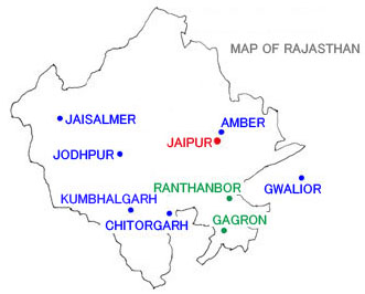
In and around Rajasthan State, western India, remain many Rajput forts. Among them six hill forts soaring from plains or cities were inscribed on the UNESCO World Heritage List in 2014. Its purport is not amply clear, allowing us to think that it is rather more appropriate to inscribe, in the first place, the city and fort of Jaisalmer alone. Anyhow, the selected sites are citadels on hills in Chitorgarh, Kumbhalgarh, Amber, Jaisalmer, Ranthanbor, and Gagron in Rajasthan State. However, since I have not visited or taken photos of those of Ranthanbor and Gagron, I cannot introduce those two here. So I intend to add two other sites instead, though not selected for the UNESCO List but more famous, Jodhpur and Gwalior (only this is in Madhya Pradesh State) as reference. It is almost impossible to treat those many sites in detail, as any one of them is worthy to be inscribed independently to UNESCO; I will only show the outlines of their citadels, based on the descriptions in ÅgThe Guide to the Architecture of the Indian SubcontinentÅh. Skimming through this page about so many sites, the image of the Åehill fortÅf could be easily grasped. First of all, it is important to know about the notion of ÅeRajputÅf. Western India consists of two states, Gujarat to the south and Rajasthan to the north, which means the Åecountry of RajputsÅf. After the 5th century the people coming from Central Asia amalgamated with natives in western India into a militaristic clan. They were Sanskritized, professing themselves to be descendants of Kshatriya (cast of kings and warriors) and established kingdoms in various regions in western India. They were called Rajputs. Among them was a tribe who advanced to central India and constructed exquisite temples in Khajuraho, the Chandella dynasty. However, it is the arid culture of Rajputs in the Rajasthan region who display most brilliantly Indian images like the scenes of ÅeThe Thousand and One NightsÅf.
The state of Rajasthan, not facing a sea and embracing few rivers, brought up a captivating cultural climate through the fusion of native and western cultures over the dry earth. While Rajasthan literally means the country of Kings (Rajas), this region had been called ÅeRajputanaÅf (land of Rajput) before the independence of India.
Since the Rajasthan region was incessantly raided from the west from ancient times, and small states struggled with each other until modern times, without cessation in the maelstrom of war, there exist almost nothing of ancient architectural remains and most of its medieval temples have been destroyed. Their forts were often constructed on hills for effective defense, forming citadels including lordsÅf palaces and inner cities.
While the Mughal forts, whether they be in Agra, Delhi, Fatehpur Sikri, or Lahore, are all located in flat areas, Rajput kings frequently built their citadels on a hill, also convenient when fighting against Mughals, with of course many exceptions in Udaipur, Bikaner, and so on on, found on flat land. Åi03/10/2015 Åj
 About 250km south of Jaipur in Rajasthan State
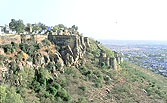
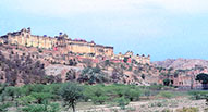
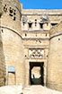
The city of Chitorgarh (also known as Chittorgarh or Chittor) has, on its eastern side, a long and narrow independent hill, soaring up to about 150m above the plain. With its width of about 1km and its length of about 5km, this huge hill, guarded by precipices around, was the capital city of the Mewar Kingdom, celebrated as an impregnable fort.
When going up to the top of the hill through several gateways, one can look out over the surrounding plain up to the horizon. In the extensive area on the hill, too large to walk around, are scattered here and there old and new palaces, Hindu and Jain temples, and large and small reservoirs, moreover very fortunately there still exist two medieval stone towers: the Hindu ÅeTower of VictoryÅf (Jaya Stambha) and Jain ÅeTower of FameÅf (Kirti Stambha).
 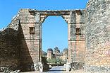 Fort of Chitorgarh
Å@On the ramp-way from the lower town to the citadel on the hill seven gates occur successively, among which the Ram Gate (Pol) is the final. Like the palace buildings in the citadel, those gates are made without using arch structure but with traditional corbelling.
 About 300km southwest of Jaipur in Rajasthan State
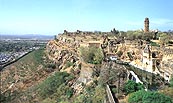
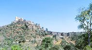
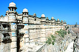
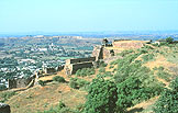
The hill fort that is furnished with the most impressive ramparts among those of all the Rajputs is the Kumbhalgarh Fort. It is located in the depth of the mountainous region over 1,000 meters above sea level, occupying vast area with a large variety of levels, enclosed with strong meandering ramparts. There was once a town of the Mewar Kingdom here, and the fort was the second most important in the state after that of Chitorgarh. Although the houses have been entirely lost now, there still remain many Hindu and Jain temples, the number of which is said to have been 365 at one time.
At the top of the highest hill soars the Badal Mahal (Cloud Palace) from the 19th century, the zigzag way to which is protected by several gates. From this palace, built to Islamic tastes, one can get fine views of most of the fort and surrounding landscape.
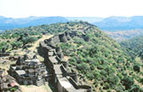  Fort of Kumbhalgarh
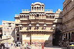
 About 11km north of Jaipur in Rajasthan State
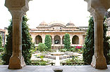
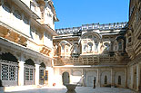
Among the mountainous area 11km north from Jaipur is the hill fort of Amber (also known as Amer), in the erstwhile state of Dhundhar. It has a great palace complex on the breast of the mountain and a town at its foot, formerly the capital of the Kacchawaha Rajput, before the relocation of the capital to Jaipur in 1727. The palace complex embraces a long extensive area, built in a mixed style of Islam and Rajput. There are four courtyards in a row from the north, the third of which, beyond the Ganesh Pol (gate), forms a kind of Islamic paradise garden like that of the Alhambra in Spain. The Jai Mandir Palace (equivalent to Diwan-i-Khas in Islamic terms) in front, built by King Jai Singh in 1639, displays a gorgeous interior design full of inlaid work and mirror mosaics, conjuring up images of resplendent court life in bygone days.
  Fort of Amber (Amer) Jaipur, the current capital of Rajasthan State, is a scrupulously planned city from the 18th century. Maharaja (king) Sawai Jai Singh II, having resided in the hill fort of Amber, constructed a new city on a plain 11km south of Amber in 1727, designating it Jaipur after his own name. The city consisted of nine sectors of 800 meters square each, the central one of which was allocated to the court area, which contained not only palaces but also a unique Jantar Mantar (Observatories). As most buildings in Jaipur were painted pink, it is popularly called the ÅePink CityÅf. This well-regulated old city, based on an accurate grid system, is a forerunner of the modern city planning of 200 years later.
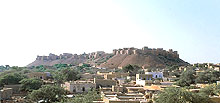
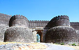
 About 480km west of Jaipur in Rajasthan State
The medieval city of Jaisalmer, left in the center of the vast Thar Desert, presents us with original picture of the old Rajput culture as it was. All the cityÅfs buildings were built of yellow sandstone in the same color as the sandy land, moreover the surfaces of their walls is entirely carved magnificently. As they shine yellowish under the sun, the city are often called the ÅeGolden CityÅf. Jaisalmer prospered as a transit town for the camel caravans just as Palmyra in the Syrian Desert, levying considerable tolls. While the kingÅfs family of Jaisalmer were Hindu, Jain merchants lead the economy to a higher state, making the city magnificent physically too. However, in the age of British rule, in accordance with the thriving of maritime commerce, the trade route in the desert gradually declined. In addition, the national border between India and Pakistan was closed by the Partition of 1947; and the city of Jaisalmer was completely forgotten.
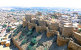
  Fort of Jaisalmer The fort constructed on the Trikuta (three ridges) Hill, soaring to 76m from the plain, is a ÅecitadelÅf that embraces an inner town for citizens. The ramparts were erected in parallel, high and low, with roughly 100 semicircular Burjs (bastions), displaying a quite impressive figure. Most bastions were added in the 17th century in order to provide batteries and the inside of them were used as houses for guards and armories.
One goes through the Suraj Pole (Gate of the Sun) and walks up a ramp to the Hawa Pol (Gate of the Wind), beyond which is the Royal Square surrounded with royal palaces. The five palaces, from the Zenana Mahal (palace for women) of the 16th century to the Gaj Vilas (kingÅfs palace) of the 19th century, indicate the augmentation of decorativeness in design, which also reflected the gradual prosperity of Jaisalmer as a transit port in the desert for east-west trade. Along with the accretion of European influence on the lifestyle of the royal family and the outgrowing of old palaces, new palaces were needed; two palaces, the Badal Vilas and Jawahar Niwas, were built in the lower city at the end of the 19th century. At present the Royal family live in the former palace, and the latter has been converted into a hotel. Architecturally both were constructed in the traditional style with comparatively small influence from Europe.
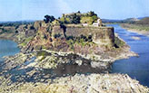
 About 110km southeast-south of Jaipur in Rajasthan State
As I have not visited this fort or taken photographs, I will only reproduce here a photo from "The Forts of India" by Virginia Fass, 1986.
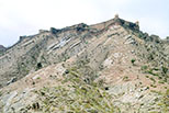
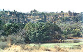
 About 250km south of Jaipur in Rajasthan State
I have also not visited this fort or found any information about it, I can only reproduce here a photo from ÅgGoogle MapsÅh from the net.
 About 270km west-southwest of Jaipur in Rajasthan State
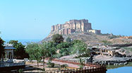
Jodhpur is a typical city spread around a hill fort in western India. From the western edge of this town to the frontier with Pakistan is the vast desert of Thar, and it was the capital city of the princely state of Marwar. Although its history can be traced back to the 13th century when the Rathor Rajput founded the state, the current city was established in 1459 by Prince Rao Jodha, so it was designated Jodhpur. The city prospered as a pivot of east-west trade, and the offshoots of JodhaÅfs royal family created Rajput monarchies of Bikaner, Pokaran, and Barmer. Jodhpur is now the second largest city in Rajasthan after Jaipur. The castle-palace complex, called Meherangarh Fort or Sun Fort, on the rocky hill 120m high on the plain, overlooking the whole town, is the cityÅfs symbol seen from everywhere, at the foot of which is a well-planned Sardar Market with a monumental clock tower. A new palace was constructed in the 20th century in the new area beyond the railway. The royal family still lives in one wing, while the other has been converted into a deluxe hotel.
  Meherangarh Fort
The soaring Meherangarh Fort is especially impressive among the large number of forts in Rajasthan. It should intrinsically be visited on foot up the long ramp-way, looking down upon the town, but nowadays one can reach the entrance of the fort in very little time by car.
 About 250km east-southeast of Jaipur in Madhya Pradesh State
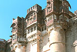
Gwalior, having a history of 1,000 years, is the northernmost large city in the Indian state of Madhya Pradesh, only 120km south from Agra. Though it was originally a Hindu kingdom, it was Islamized after the conquest by Sultan Iletumish of Delhi in 1232. Despite recapture by Man Singh of the Tomar Rajput in 1486, who constructed the current fort, it fell again into the hands of the Lodi dynasty of Delhi in 1516. Resembling the configuration of Chitorgarh in western India, Gwalior has a huge flat hill stretching close to three kilometers at a height of about 100m on the plain. This soaring hill once formed the capital city and fort. It embraces old Hindu temples, the palaces of Man Singh, and Jain caves, with statues of Tirthankaras, at its foot. In the lower city, northeast of the hill, are the Friday Mosque and other Islamic buildings. The new palace and new city have spread to the south.
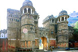  Fort of Gwalior It must be the Man Mandir Palace built by Man Singh that is the most captivating among the fort-palaces of many Hindu kingdoms. Though the term ÅeMandirÅf usually indicates a temple, it is sometimes used for a grand building such as this palace. Going through the Hindola Gate at the foot of the hill, one ascends a long zigzag slope in a wide curve, looking pleasantly down upon the lower town. On the right hand rises precipitously the citadel over 120m in height, to which continual rounded buttress-like turrets give a rhythm.
Turning up the slope, one reaches the magnificent Hathia Pol (Elephant Gate), which forms the main entrance to the citadel. After that, one follows a path to temples on the left, or palaces on the right.
E-mail to: kamiya@t.email.ne.jp
|